After a mild and rainy end to 2021, 2022 is already looking a lot colder from the start.
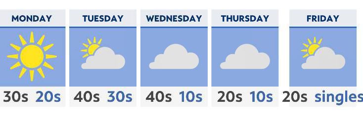
With leftover flurries leaving the northeastern areas, we’ll be left with a very cold but clear start to the workweek. Monday is mostly sunny, dry and chilly, with temperatures in the 30s. In many areas, even as far south as central Ohio, highs on Monday may not get much above the freezing mark.
Monday night is no doubt one of the coldest nights of the season so far. Expect lows to be in the upper teens and low 20s.
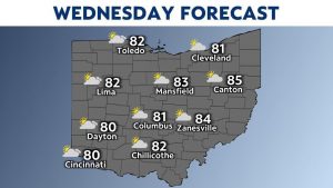
Partly cloudy and chilly weather extends into Tuesday and the beginning of Wednesday.
Beyond that, we’re tracking yet another cold front that will be Arctic in nature, moving in Wednesday night into Thursday. While many things may change before that time, it’s looking a little more likely that we might see our first decent statewide snow event Thursday into Friday.
Temperatures will cool down significantly by the end of the week with this front; expect highs to be in the 30s Thursday and only the 20s on Friday. This will support accumulating snow.
By late in the week and into next weekend, a few areas may even see overnight lows in the single digits. Stay tuned as real winter arrives in Ohio.