After a gorgeous weekend with highs well into the 80s, a powerful cold front will push Ohio back to early spring- and even late winter weather for the week ahead.
What You Need To Know
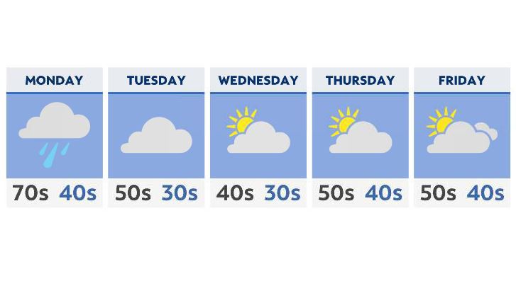
- Monday brings rain to the entire state
- Below average temperatures are back in the forecast starting Tuesday
- A few light lake-effect snow showers possible Wednesday
- Quiet but cool weather expected by the end of the week
Monday is the transition day, with clouds, showers and even a few thunderstorms moving across the state with our next front. Expect 60s and 70s along with the rain, before the air significantly cools down Tuesday morning.
The good news is that if you’re craving sunshine, most of the week should provide a decent amount.
After clouds clear on Tuesday, expect mostly sunny to partly cloudy skies through at least the end of the week. The bad news? Clear skies combined with NW winds overnight will give many areas lows Wednesday and Thursday that could flirt with the freezing mark.
A weak system may even give the Cleveland area and NE Ohio a few light lake-effect snow showers Wednesday!
Thursday and Friday look dry and cool, with most areas still averaging 10 degrees below average for high temperatures. We’ll end the week with a slight uptick in the mercury, with partly cloudy skies.