The disturbance that brought heavy rain and flooding concerns across South Florida and the Bahamas on Saturday has become Tropical Storm Alex, the first named storm of the Atlantic hurricane season.
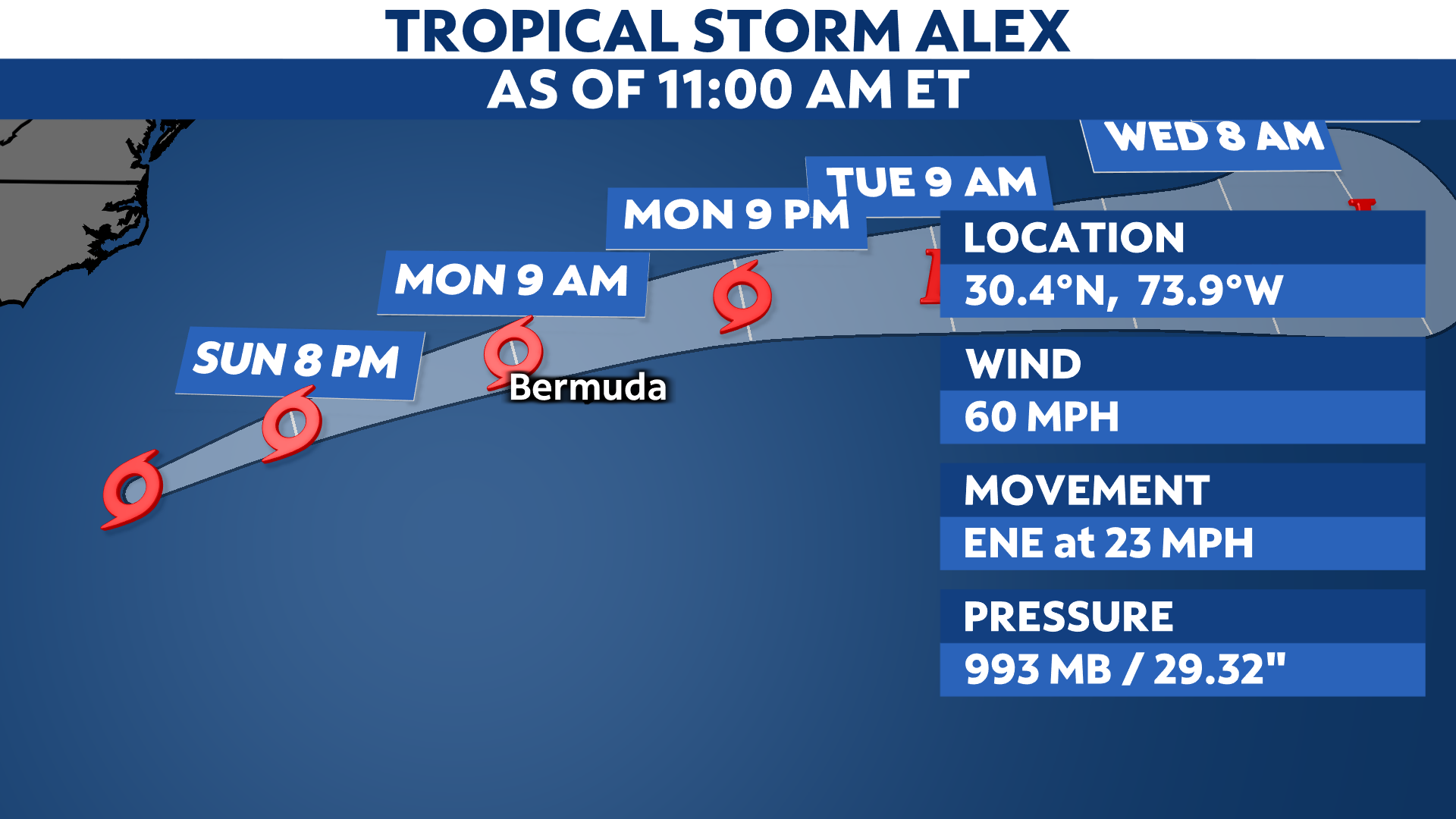
Alex formed early Sunday morning in the Atlantic, just about 165 miles east-northeast of Fort Pierce, Florida. While most of its effects continue to subside for the U.S., we expect Alex to bring heavy rain and gusty winds to the island of Bermuda on Monday.
Since the last update early Sunday morning, Alex has strengthened, moving east to northeast toward Bermunda.
Alex started as Agatha in the eastern Pacific, which formed early Saturday morning on May 28. It became a hurricane a day later before making landfall last Monday in southern Mexico.
It fell apart into a remnant disturbance Tuesday morning before moving into the Gulf Mexico. However, the disturbance struggled to regain its strength as it moved towards the northeast.
While wind shear and drier air aloft actually weakened this lopsided system on its approach to South Florida Friday night into Saturday, it still brought heavy rainfall and flooding.
The disturbance regained its strength and better organization upon moving off the Florida coast Saturday night and became the first named storm of the season early Sunday morning, Tropical Storm Alex.
Despite generating rough surface and dangerous rip currents along the east coast of Florida today, most of Alex’s impacts will stay offshore, away from the U.S. mainland.
Alex could strengthen over the next day or so, but we expect it to remain a tropical storm as it heads towards the island of Bermuda on Monday. After that, though, it will move out to sea, to weaken this week.

A Tropical Storm Warning is in for the place for the island of Bermuda.

Computer model forecasts show the center of Alex’s path crossing near or north of Bermuda on Monday before heading out to sea.

Spaghetti models or plots show a series of individual computer forecast models together on one map. They are useful to give insight into whether multiple models are in agreement or not on the path of the storm but they do not address the storm’s forecast intensity, winds, flooding and storm surge potential or other data. Tap here for more details on how to best use these models.
Deadly storm
Before the storm was Alex, it was Potential Tropical Cyclone One. The system brought flooding rains to parts of South Florida. Heavy rains from the storm caused flash flooding in Miami.
In addition, the National Weather Service in Miami says several areas got more than a foot of rain from PTC One.

Young boys paddle an inflatable kayak on a flooded Miami street, Saturday, June 4, 2022. (AP Photo/Marta Lavandier)
The storm also brought flooding rains to Cuba. The Associated Press reports three people died from the storm that hit the island.
Plus, before it became Alex, the remnants of Hurricane Agatha killed at least 9 people in Mexico last week as the storm crossed over from the Pacific into the Atlantic.
Pacific-Atlantic crossovers
A tropical disturbance crossing from one basin to the other isn’t especially rare, although it’s usually the remnants regenerating instead of an intact system surviving the crossing. And, the more common direction is Atlantic-to-Pacific, not vice versa.
For a recent account of remnants from one basin redeveloping in the other, that happened just last year. The Atlantic’s Grace dissipated over Mexico, but its remnant circulation became Marty in the Pacific. In 2020, Amanda in the Pacific fell apart but led to Cristobal in the Atlantic.
Over the past 50 years, 12 tropical systems remained fully intact while crossing basins. The last was Otto in 2016, tracking from the Atlantic to Pacific. Going the other direction, the most recent storm was Hermine in 2010.