OHIO — With rain coming to an end Monday, we’ll have a chance to significantly dry out and warm up, with near heat-advisory feeling like temperatures possible for parts of Ohio in the week ahead.
What You Need To Know
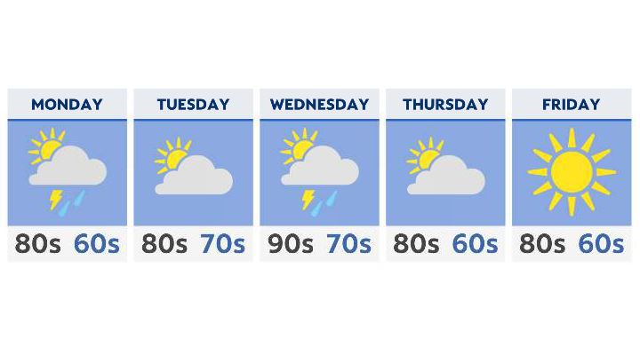
- Rain and a few rumbles kick off the week on Monday
- Tuesday is breezy, very warm and mostly dry
- Heat and humidity return Wednesday, with a chance of storms
- Mainly dry but very warm to end the week
The rain on Monday will be moving east and out, leftover from the same storm system that’s currently moving through over the weekend. There may actually be a bit of sunshine returning by late Monday afternoon.
Tuesday is a relatively dry day, although we’ll definitely start to feel the humidity returning to the Buckeye State.
Warm air advection, or the transport of air from the south- will play a big part in increasing our humidity levels and instability come Wednesday. With the added humidity, Wednesday’s temperatures (which will already hit the low and middle 90s) will have the potential to feel well above 100 degrees.
This may very well put a few areas into heat advisory territory.
With an approaching front Wednesday afternoon and evening, showers and storms will develop, with some of these strong to severe. Gusty winds seem to be the main threat as of right now.
Beyond that, we’ll have a chance to dry out but also stay very warm for Thursday and Friday. Expect high temperatures to stay in the upper 80s to near 90 for the end of the week.