OHIO — As August wraps up this week, expect a full gamut of weather, including high heat, humidity, chances for storms, and a very comfortable cool-down by week’s end.
What You Need To Know
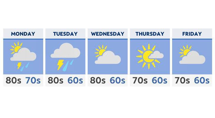
- A soaking start to the week Monday and Tuesday
- Highs early on: well into the 80s to near 90
- Drying out Wednesday into Thursday
- 70s for highs across the state Thursday and Friday
Clouds and humidity return for early Monday, with highs by the afternoon once again reaching the upper 80s and low 90s. It’ll definitely feel a bit more like the middle, rather than the end of the summer.
By the afternoon, rain will move into the state, with a few heavy downpours along the approaching front, by overnight and into Tuesday morning.
Budget extra time in for the Tuesday morning commute, statewide.
A bit more of the right incgredients may come together by late Tuesday afternoon for severe weather. We’ll be watching for the possibility of heavy rain, gusty winds and some small hail.
Wednesday leaves us nice and dry, with a cool-down moving in just in time for the final day of August.
The remainder of the week looks clear to partly cloudy, with more fall-like weather. Slightly below average temperatures will move in, with a large portion of the state seeing highs in the mid and upper 70s.