AKRON, Ohio – Crashes in the Greater Akron area have been steadily rising in the past couple years, with over 1,000 more crashes in 2021 than in 2020, according to the Akron Metropolitan Transportation Study 2019-2021 Crash Report.
The rise from 14,965 crashes in 2020 to 15,987 in 2021 represents a 6% increase, the agency reported.
AMATS’ annual crash report takes an in-depth look at motor vehicle, bicycle and pedestrian-related crashes over the past three years in Summit and Portage counties, and northeast Wayne County.
To develop the report, AMATS said it analyzed nearly 49,000 crashes recorded by the Ohio Department of Transportation.
Crashes caused by animals and those that took place in construction sites are not included, AMATS said, because they don’t pertain to characteristics of the roads. Highways crashes, also excluded, are analyzed by ODOT.
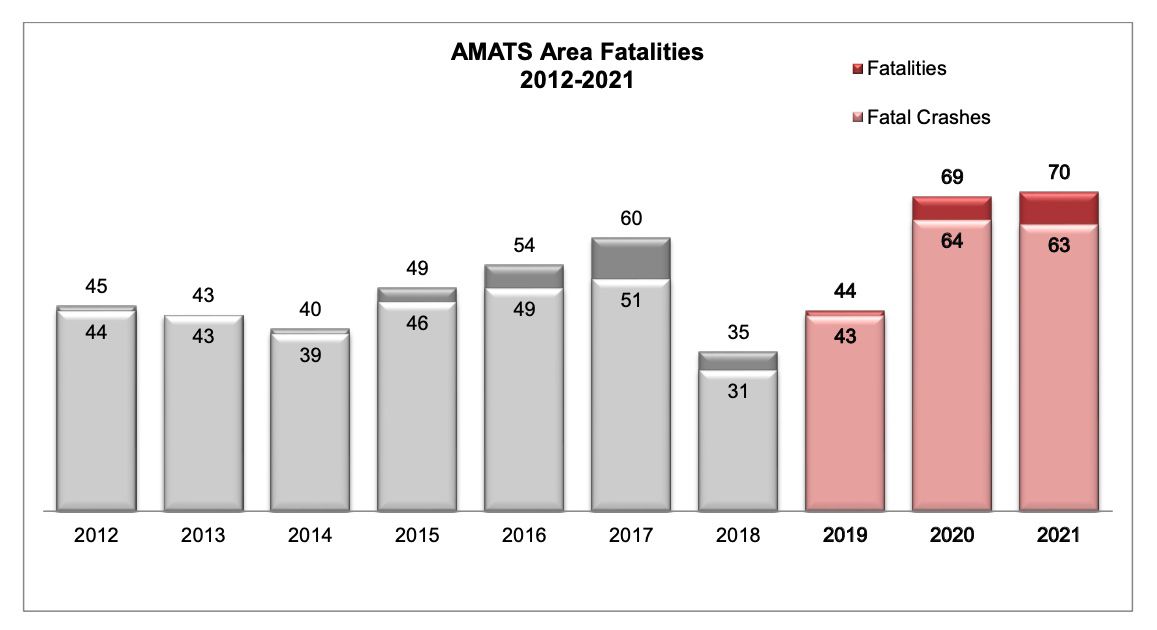
One trend over the three-year study transportation officials said they can’t explain, is the increase in traffic fatalities in 2020 and 2021, compared to 2019.
Fatalities should have decreased when the COVID-19 pandemic kept many drivers off the roads, but instead leapt from 44 in 2019 to 69 in 2020 and 70 in 2021, AMATS said.
The increase could be because lighter traffic prompted drivers to increase speeds, transportation officials said.
“It appears that the pandemic changed the nature of area crashes and fatalities,” said AMATS Transportation Engineer David Pulay. “Hopefully, not permanently.”
AMATS 2019-2021 report also identified high-crash areas and intersections within the study region.
High-crash road sections
Across the study area, AMATS identified 143 high-crash sections.
To be considered a high-crash section, the roadway had to have three or more crashes per mile/year over the three-year study period, with at least 30% of the crashes fatal or injury-related, AMATS said.
AMATS identified a section of road as a length of road between two end-points, which can be intersections with other roads, the agency said. A section of road can vary from a shorter stretch in urban areas to potentially miles long in rural areas.
The top 10 high-crash road sections in the study area include:
- State Route 59 from Alpha Drive to state Route 261 in Franklin Township
- Massillon Road from Krumroy Road to Oaks Drive in Springfield Township
- River Street from Haymaker Parkway to West Main Street in Kent
- M.L. King Boulevard from West Market Street Overpass to North Broadway Street in Akron
- South Cleveland-Massillon Road from Interstate 77 to Rosemont Boulevard and Elgin Drive in Fairlawn
- State Route 43 from Kent North Corp Line to Streetsboro South Corp Line in Franklin Township
- Arlington Road from Greensburg Road to Turkeyfoot Lake Road in Green
- Copley Road from Storer Avenue to East Avenue in Akron
- East Main Street from Freedom Street to state Route 14/state Route 44 in Ravenna
- Norton Avenue and Fairview Avenue from Wooster Road North to 5th Street Northeast
High-crash intersections
AMATS also identified 231 high-crash intersections.
To be considered high-crash, the intersections had to have at least nine crashes over the three-year period, with at least 30% fatal or injury-related, AMATS said.
Crashes are considered intersection-related when at least two vehicles are involved in a crash that happens within a 250-foot radius of the center of an intersection, AMATS said. Driveway-related crashes and those at non-intersection areas, such as vehicles leaving an intersection, are not included.
The top 10 high-crash intersections in the study area include:
- Medina Road and Medina Line Road
- State Route 14 and state Route 44/North Chestnut Street
- North Howard Street and Glenwood Avenue
- State Route 261 and Mogadore Road
- State Route 82 and Mantua Center Road
- U.S. Highway 224 and state Route 225
- Cleveland Massillon Road and Eastern Road
- State Route 82 and Chamberlain Road
- State Route 88 and state Route 305
- State Route 59 and Rhodes Road/Ashton Lane
Bicycle and pedestrian-related crashes
AMATs also evaluated bicycle and pedestrian-related crashes, which have a high percentage of injuries, the agency said.
Of 200 bicycle-related crashes, the majority of which happen away from intersections, 151 of them, or 75.5%, resulted in an injury with eight resulting in a fatality, the agency said.
Out of 382 pedestrian-related crashes in the three-year period, which also occur most often at non-intersections, 319 or 83.5% of them resulted in an injury with 26 resulting in a fatality, AMATS said.
The agency recently asked for assistance from the public in crafting an action plan to improve some of the most unsafe roadways in the region. An online survey, where residents can give input, will be available through Jan. 6.
To learn more about transportation safety, visit the AMATS website, where the AMATS 2019-2021 Crash Report is available for download.

Fatalities didn’t decrease when the COVID-19 pandemic kept many drivers off the roads — they leapt from 44 in 2019 to 69 in 2020 and 70 in 2021. (Graphic courtesy of AMATS)