An incredibly cold and dangerous arctic air mass will impact much of the U.S., including all of Ohio. Winter weather will take center stage with frigid temperatures, strong wind gusts, and falling snow late Thursday night into Friday.
The timing could not be worse, as Friday is a major travel day before the Christmas holiday weekend.
With such an impactful winter storm pending, it may be a good idea to finish up any last-minute shopping or errands early.
The forecast for Wednesday is dry and quiet. Clouds will be increasing by Wednesday afternoon, with high temperatures reaching the upper 30s and lower 40s in most parts of the state.
If possible, perhaps make Wednesday or even early Thursday your travel days.

While it is certainly fitting that an air mass originating near the North Pole will impact our Christmas holiday forecast, this type of cold can be quite dangerous. Temperatures will likely be in the 30s and 40s late Thursday night right before the cold front arrives.

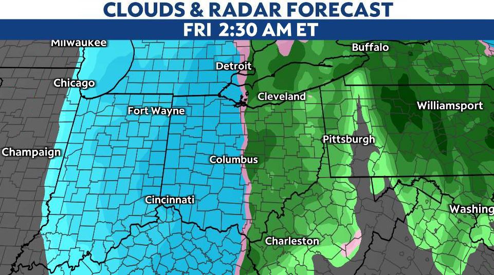
As the arctic air meets up with the ongoing rain, precipitation will quickly transition to snow.
Temperatures will then plummet through Friday morning into the teens and single digits by lunchtime. Any wet roadways and sidewalks may be subject to a flash freeze and will become slippery.
The cold air continues through the weekend, with highs in the teens and lows in the single digits, and even colder wind chill values.
Powerful winds
Winds will increase out of the south-southeast on Thursday night ahead of the cold front. Once the front passes, strong west-northwest winds will begin to howl. Wind gusts may approach 40 to 50 mph overnight and through much of Friday.
Wind gusts may approach 60 mph at times, especially in northern Ohio.
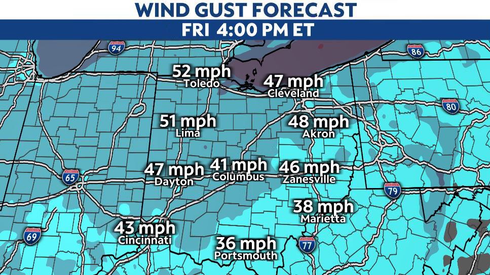
The strong winds will bring several threats. First, whiteout conditions will be possible with falling snow on Friday.
The snow will continue to blow and drift (especially in open areas) into Saturday. Second, wind chill values will reach levels that will make frostbite possible for those exposed to the cold air long enough. It may feel as cold as 10 to 20 degrees below zero at times throughout Friday and the weekend.
Lastly, scattered power outages are possible, which could lead to the loss of heat. This would be very concerning, considering how cold it will be.
Snow totals
The snowfall forecast for this system has been a bit tricky. A quick changeover from rain to snow will happen late Thursday night into early Friday morning right along the cold front.
There will likely be a brief burst of snow, but then there is some discrepancy as to how long the snow lasts into Friday. The exact track of low pressure will make all the difference in regards to how much snow we see across the state.
While totals will not be the biggest headline, snow-covered roads and sidewalks will still be slippery and travel will be tough on Friday.
Models have been trending with just a few inches across central and southern Ohio.

Meanwhile, several inches are likely in northern Ohio. Some of the highest totals may be found in far Northwest Ohio, closer to the Indiana border. Lake-effect snow will develop into Saturday in Northeast Ohio, so totals should be a bit higher in the Snowbelt as well.
A better idea of the timing and totals for snow will likely be realized on Wednesday. We will continue to keep you updated with the latest forecast information.