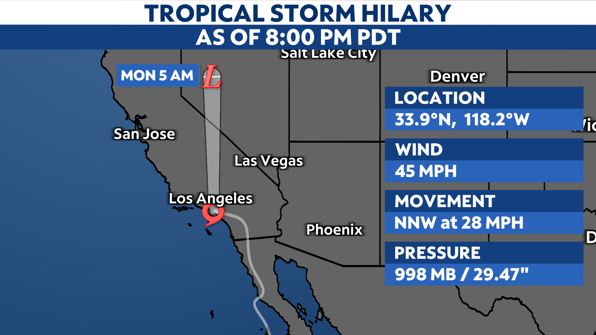
The core of Tropical Storm Hilary is moving near the coast of Southern California.
Hilary made landfall over the northern Baja California Peninsula around 11:00 a.m. PT on Sunday.
Even though Hilary remains a tropical storm, it is still expected to bring significant rainfall, flooding and gusty winds to parts of the Southwest U.S., including Southern California and Nevada through Monday.
The center of Tropical Storm Hilary will move over SoCal Sunday night into Monday. The storm is producing maximum sustained wind speeds of 45 mph and is about 105 miles northwest of San Diego.
Continued weakening is expected as the storm interacts with land and cooler waters, but drier air and wind shear will also contribute to its deterioration as it heads northward.
Hilary is forecast to remain a tropical storm as in moves over Southern California today before becoming post-tropical as it tracks over the western U.S. tonight into Monday.
Regardless, it is still expected to bring catastrophic and life-threatening flooding and powerful winds across the Baja California Peninsula and portions of the Southwest U.S.

For the first time in its history, the National Hurricane Center (NHC) has issued a Tropical Storm Warning for parts of coastal Southern California, which remains in effect from the border of Mexico to Point Mugu and Catalina Island.
Hurricane Watches and Warnings have been dropped for portions of the Baja California Peninsula, but Tropical Storm Warnings remain in effect.

Tropical-force winds and conditions will continue for parts of Baja California before extending into Southern California on Sunday.
Here’s a look at Hilary when it made landfall in Baja California.
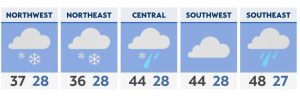
Hilary will bring widespread heavy rainfall totals between 3 to 6 inches across parts of Southern California, with higher amounts reaching as much as 10 inches in some select spots inland areas. Locally heavy rain could cause flooding, and burn scars will become especially susceptible to problems.
Widespread Flood Watches are in effect through Monday morning.
Rain from Hilary will continue to stretch into Southwest Sunday morning, and will intensify as the center of the storm moves over Southern California during the afternoon and evening. The heaviest rain will move out as the storms heads north Sunday night into early Monday morning.

We can also expect gusty winds and hazardous marine conditions as the system approaches and moves through. A few tornadoes could even spin up across the most southeastern deserts.
Hilary became a named storm on Wednesday, Aug. 16, 2023 and then intensified into a hurricane Thursday morning, then a major hurricane Thursday evening. It’s the fourth major hurricane of the 2023 Pacific hurricane season.
The last tropical system to pass within a couple hundred miles of Los Angeles was Nora in 1997. It went from a tropical storm to a tropical depression as its center straddled the California-Arizona border.
Our team of meteorologists dives deep into the science of weather and breaks down timely weather data and information. To view more weather and climate stories, check out our weather blogs section.