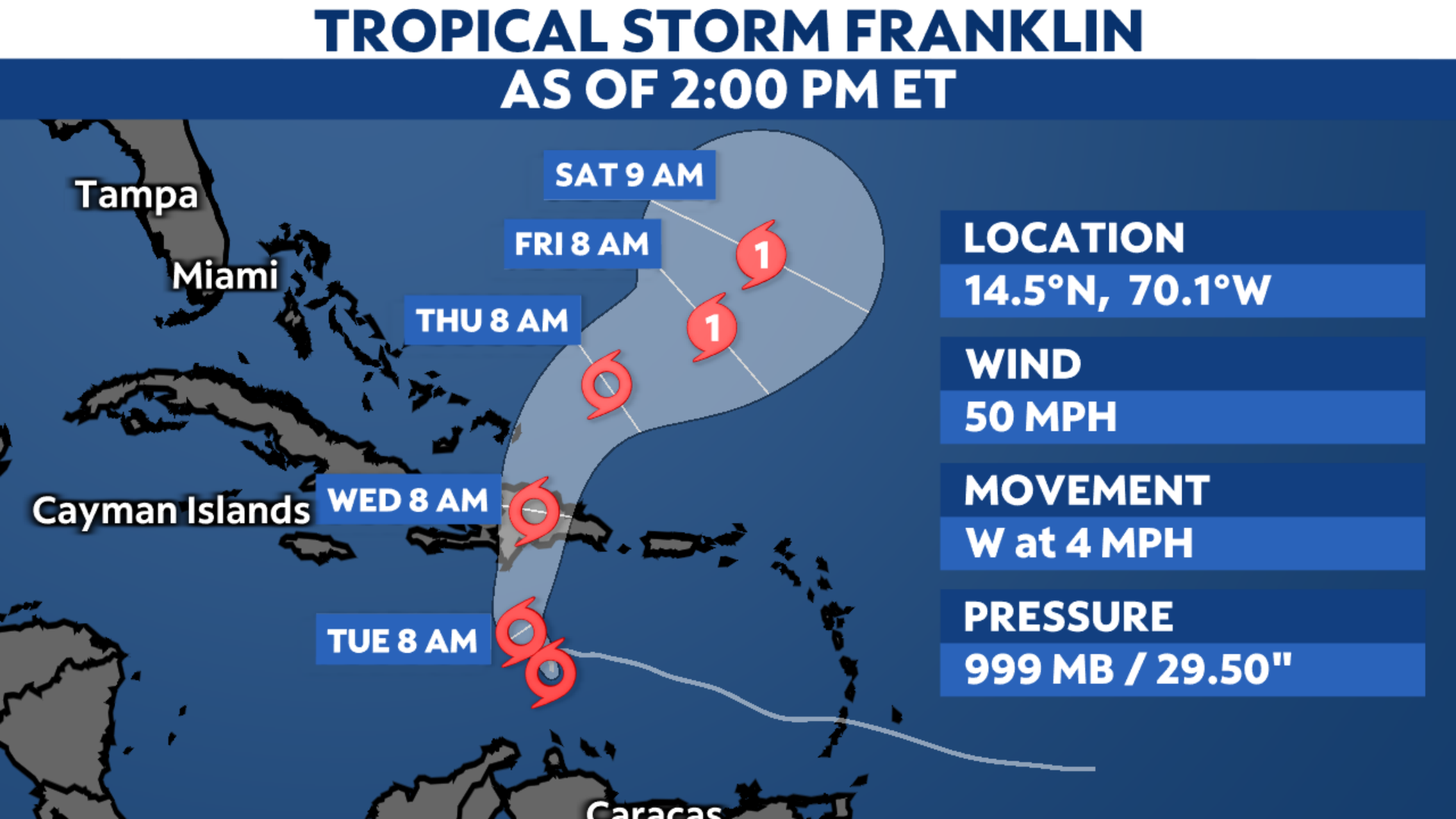
Franklin remains a tropical storm over the Caribbean Sea. Even though it is heading west, it will take a hard turn to the north late Monday night or early Tuesday before heading toward Hispaniola.
Franklin formed on Sunday, Aug. 20, becoming the sixth named storm of the 2023 Atlantic hurricane season. While it will continue to head west over the Caribbean Sea on Monday, Franklin is forecast to make a sharp turn toward the north Monday night or early Tuesday morning.
Despite not much change in strength since developing, Franklin is still producing maximum sustained winds of 50 mph. Yet, it could gain some intensity before moving over Hispaniola by midweek.

Franklin is expected to bring tropical storm conditions to the Dominican Republic, Haiti and the Turks and Caicos Tuesday night into Wednesday before it pivots toward the northeast on Thursday.
Tropical Storm Warnings are now in effect along the southern coastline of Hispaniola, with Tropical Storm Watches in effect for the island’s northern shores and for the Turks and Caicos.

Parts of Hispaniola will see the heaviest precipitation from Franklin, with southern portions of the Dominican Republic receiving anywhere between 5 to 10 inches of rain. Yet, some select places could see rainfall totals add up to over a foot.
Even though the center of Franklin will move over the Dominican Republic or Haiti, its outer bands will still likely clip Puerto Rico, bringing the island heavy rainfall and gusty winds as well.
While no tropical alerts have been issued for Puerto Rico, widespread rainfall totals between 2 to 4 inches are possible through midweek, with locally higher amounts reaching up to 6 inches in spots.

In addition to powerful winds and rain, Franklin will also generate large swells and dangerous rip currents, especially along the southern shores of Hispaniola prior to making landfall later on Tuesday.
Once Franklin moves over Hispaniola, it then will curve toward the northeast later this week, where it could eventually become a hurricane out over the open waters of the Atlantic.
We’re currently monitoring a few other areas with the potential to develop across the Atlantic basin, along with Tropical Storm Gert and Potential Tropical Cyclone Nine.
Check here for a look at the 2023 Atlantic hurricane season so far.
Our team of meteorologists dives deep into the science of weather and breaks down timely weather data and information. To view more weather and climate stories, check out our weather blogs section.