OHIO — After last week’s below average temperatures, the week ahead will be much hotter and noticeably more humid. It will certainly be feeling like summer across Ohio, and that includes the chance for pop-up showers and thunderstorms almost everyday.
What You Need To Know
- Unsettled weather kicks off the new week
- Isolated thunderstorms may reach severe limits Sunday and Monday
- Heat and humidity builds for the middle of the week
- Record highs in the 90s will be possible
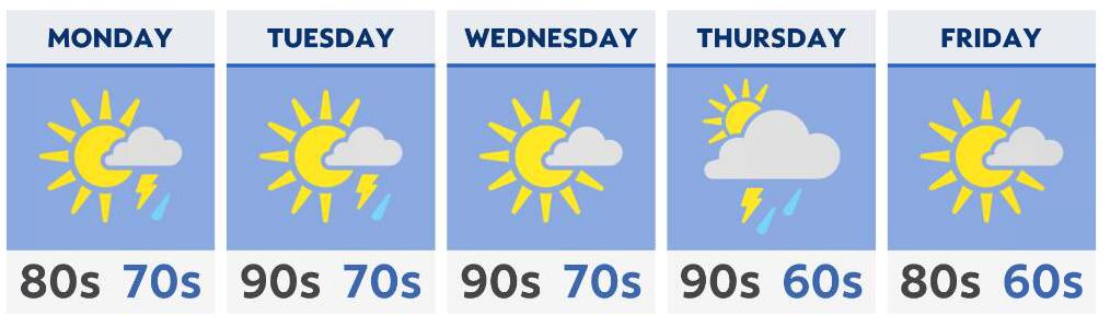
Spotty showers and thunderstorms will dot the sky and the radar on Sunday and Monday. A few thunderstorms may reach severe limits with strong wind gusts and sizable hail. The overall nature of these thunderstorms will be hit-or-miss, meaning not everyone will be impacted.
A possible concern may arrive Monday night into Tuesday morning with a complex of thunderstorms bringing damaging wind gusts. Be sure to follow along with us as we’ll bring you the very latest weather information.
While Monday will be warm with many parts of the state reaching the 80s, highs may touch 90 in far southern Ohio. This will set the stage for a prolonged period of hot and humid weather for the middle of the week.
High temperatures are expected to soar into the 90s on Tuesday, Wednesday, and Thursday. Those living near Lake Erie will enjoy temperatures a few degrees cooler. However, humidity levels are expected to rise throughout the state. Be sure to find ways to stay cool as temperatures approach record levels.
By the end of the week, temperatures will fall back a bit into the 80s. A few passing showers and thunderstorms will also remain in the forecast.