While a storm system with winter precipitation is a certainty for parts of the eastern U.S. Sunday into Monday, the details are still unclear.
The track of a nor’easter is always crucial for determining who gets what, and the next one will follow that rule.
What do we know?
To start, it’s a safe bet that a weather system will dive into the Southeast going into the weekend, then ride up near the East Coast Sunday into Monday.
Temperatures will be cold enough to support areas of snow, with a wintry mix in the transition area to rain. Wintry precipitation will affect parts of the Carolinas, the Ohio Valley and the Northeast. Where freezing rain happens, ice accumulations could be enough to cause power outages.
On the eastern, warmer side of the system, precipitation would be mostly, if not completely, rain.
What don’t we know?
It’s still too far out to know where exactly the system tracks. Until then, confident and accurate predictions of precipitation amounts are impossible. For quite a few areas, even knowing the type of precipitation is a big question mark, let alone how much will fall.
The disturbance that’ll evolve into this weather system is exiting the eastern Pacific Ocean. While satellites can get a pretty good read on things over the open water, we’ll have more data as the disturbance moves past the West Coast.
See the differences
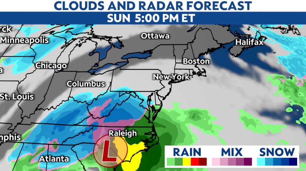
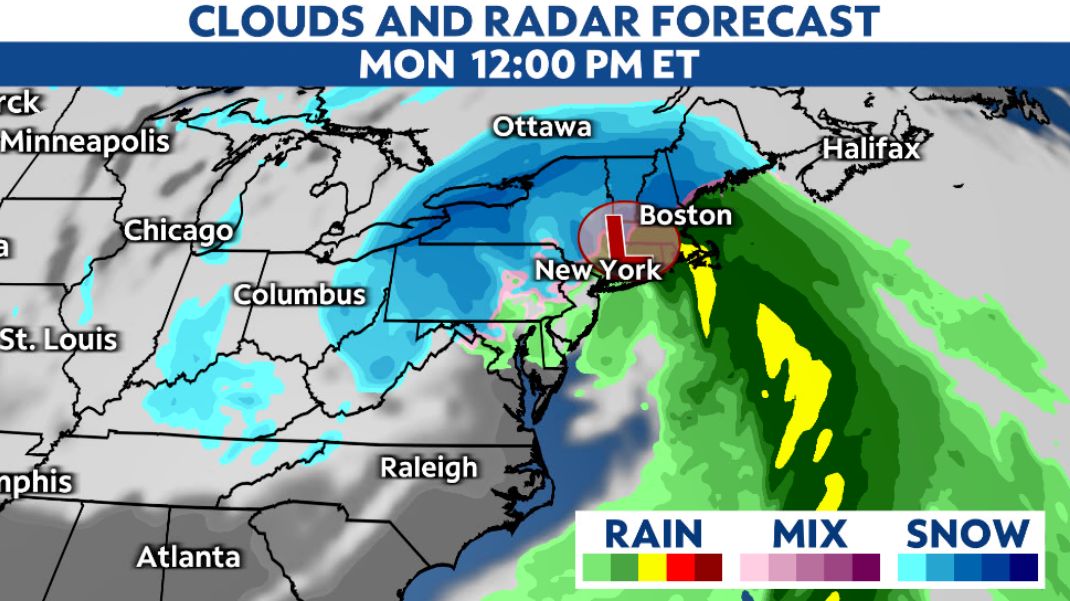
Meteorologists look at a lot of different information, but we’ll share images from two of the main global forecasting models.
These first two are what they’re predicting for 5 p.m. Sunday evening, as of Thursday.

Cloud and precipitation forecast from the European computer model Sunday evening.
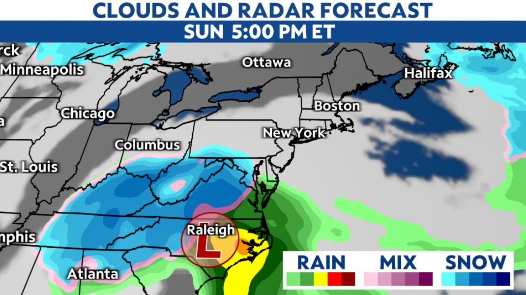
Cloud and precipitation forecast from the American computer model Sunday evening.
The next two are for noon on Monday, which is Martin Luther King Jr. Day.
Cloud and precipitation forecast from the European computer model midday Monday.
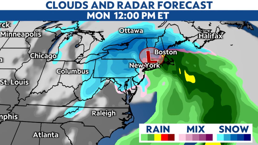
Cloud and precipitation forecast from the American computer model midday Monday.
They both show a noteworthy nor’easter, but with different tracks and impacts. In the end, neither of them will be exactly right, but this shows just how much local impacts will depend on where the system ends up going.
So, what should I do?
For now, keep checking your local forecast for updates, and don’t buy into social media hype.
If you have plans for Sunday or Monday–depending on when it arrives where you live–you may want to start thinking about shifting them as the situation becomes clearer.
Since this will happen on a Sunday into a holiday when schools and a number of workplaces will close, whatever the system brings won’t have as big of an impact on people traveling.