After a very cold weekend, the first few days of the week ahead will offer a nice warming trend, with plenty of sunshine to spare.
What You Need To Know
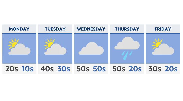
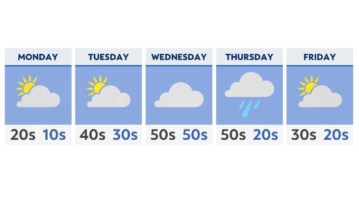
- We’ll see a cold start Monday, with highs in the 20s and 30s
- Expect plenty of sunshine Tuesday and Wednesday
- Mid-week highs will be in the 50s and 60s
- Rain is likely Thursday, with colder air and snow showers early Friday morning
While Monday is the transition day, with cold temperatures and even a few lake-effect flurries to start, we’ll see a return to more sunshine by the end of the afternoon, with highs in the 20s and 30s.
An approaching front out west will inch closer to the area Tuesday, changing our winds around from the south and southwest, and increasing the available moisture in the air as well. This will significantly warm us up by Tuesday, with highs in the 40s.
Wednesday will be the mildest day, with highs well into the 50s and 60s for many areas (the warmest temperatures will be found south of I-70). Expect mostly sunny skies with increasing clouds late in the afternoon and early into the evening.
Thursday is when the attached front moves in, with showers and even a rumble of thunder not out of the question. A soaking rain is possible Thursday night.
By Friday, colder air behind the system moves in, giving us a brief period of snow, before things clear out just in time for the weekend.