Tropical Storm Marco is moving into the Gulf of Mexico this morning, while Tropical Storm Laura brings heavy rain and the threat of mudslides to Hispaniola.
Both storms will affect the United States early next week and this could be the first time in a long time that we see two systems in the Gulf at the same time.
Marco Comes First
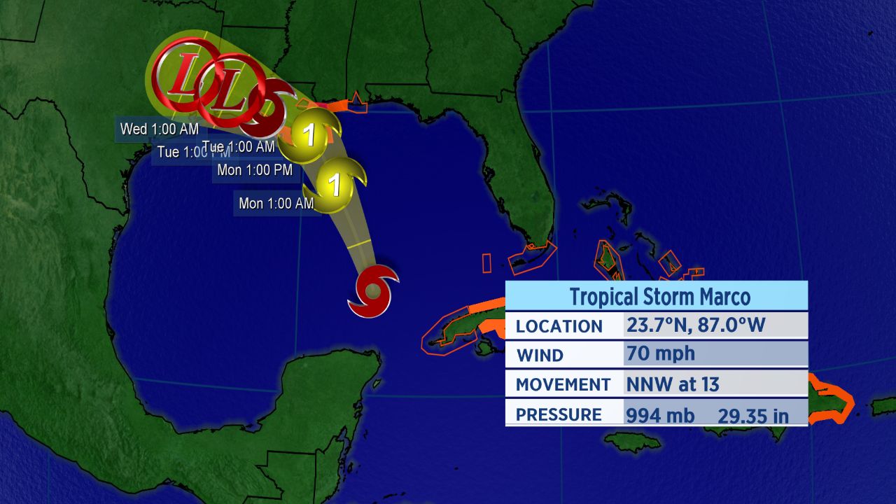
On Friday night, Tropical Storm Marco formed in the western Caribbean and it is moving into the Gulf of Mexico this morning.
The forecast track has now shifted more to east and we could see impacts anywhere from Texas to the Alabama coast. The most likely landfall location at this time is Louisiana, but that may shift.

Forecast track for Marco.
A hurricane warning is in effect from Morgan City, Louisiana to the mouth of the Pearl River. Storm surge warnings extend into coastal Mississippi. Meanwhile, a tropical storm warning is in effect from the mouth of the Pearl River to the Mississippi/Alabama border, including the city of New Orleans. Tropical storm watches stretch from the the Mississippi/Alabama border to the Alabama/Florida border.
Marco is continuing to track to the northwest Sunday morning after strengthening Saturday. It’s forecast to get a little stronger Sunday, reaching hurricane status. Impacts to Louisiana begin Monday. Marco is set to quickly weaken as it turns to the west over land.
Laura Follows A Few Days Later
Tropical Storm Laura formed in the central Atlantic on Friday and continues to move on a west track as a ridge in the western Atlantic steers it. It’s moving across Hispaniola Sunday morning.
It became the earliest “L” named storm to ever form in the Atlantic.
Tropical storm warnings and watches are in place for Puerto Rico, the Dominican Republic, Haiti, Cuba, the Bahamian islands, and the Florida Keys. The storm is bringing heavy rains to the Dominican Republic.
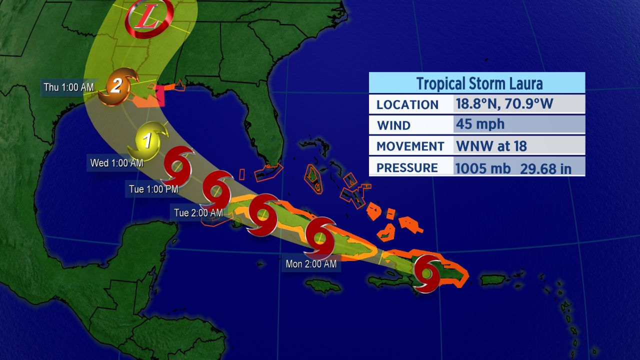
Forecast track for Laura
This storm appears to pose a direct threat to the U.S. early next week, though the track and the storm’s intensity are both in question.
There is still a lot of uncertainty with Laura. Its intensity won’t change much for now as it moves over or near land. As it moves into the Gulf of Mexico, it should enter more favorable conditions and we could see strenghthening.
Laura could also see some interaction with Tropical Storm Marco which may also impact the track and intensity.
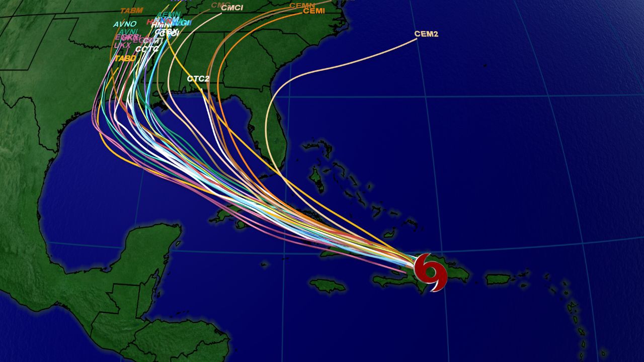
Spaghetti model data for Laura.
Spaghetti model data show some disagreement as Laura moves into the Gulf. We’ll have to keep a close eye on the storm and where it tracks.
The next name on the list is Nana.
An M-named storm had never formed in the month of August in the Atlantic before Marco.
These disturbances follow what has already been a record-setting season in the Atlantic.
With 13 storms already this year, this is the fastest start to a hurricane season in recorded history. The climatological peak of hurricane season is in mid-September.