Ian became the ninth named storm of the 2022 Atlantic hurricane season on the evening of Sept. 23. Even though it was slow to strengthen, Ian underwent rapid intensification once it become a hurricane on Monday.
Less than 24 hours later, Ian became a major hurricane, just prior to making landfall over western Cuba on Tuesday morning. While it is the fourth hurricane in the Atlantic this year, it will be the first to impact the U.S. mainland.
Even though brief interaction with land slightly weakened it, Ian remains a major hurricane in the southern Gulf of Mexico. Favorable conditions will allow it to restrengthen over the next couple of days as it heads toward the west coast of Florida.
Ian made landfall as a major hurricane just southwest of La Coloma, a town in the Pinar del Rio Province of Cuba around 4:30 a.m. on Tuesday morning.
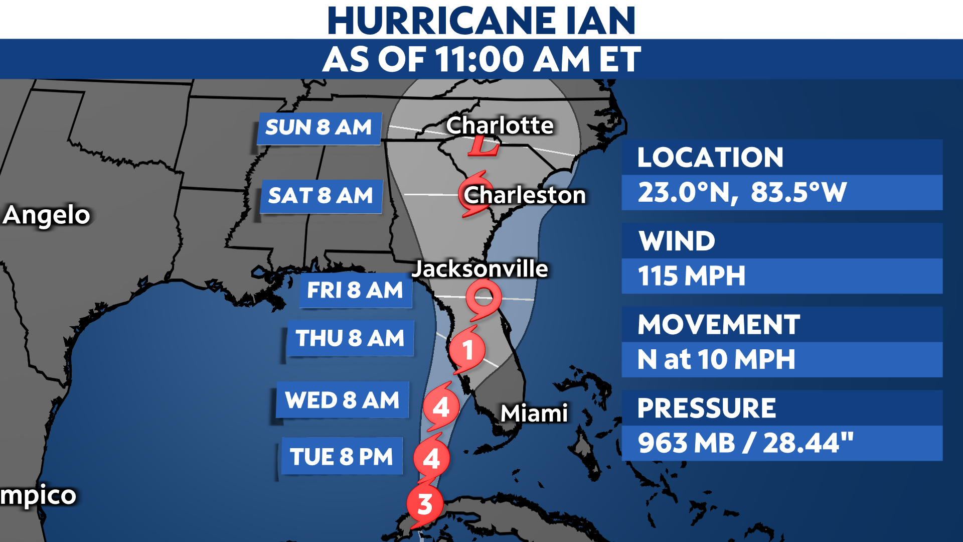
Since interacting with land, Ian has weakened slightly, with maximum sustained winds reaching 115 mph. Yet, it still maintains its status as a powerful Category 3 hurricane.
Now that Ian emerged into the southern Gulf, favorable environmental conditions will allow it to regain its strength and then some as it continues to bring tropical storm conditions to the Florida Keys and parts of southwest Florida.
It will eventually make landfall along the Florida Gulf coast later this week, making it the first to directly hit the U.S. this season.
While there is still uncertainty in both the track and intensity once it enters the eastern Gulf of Mexico, Ian will impact Florida with strong winds, heavy rainfall and storm surge later this week.

Intense winds and life-threatening storm surge continue to impact western Cuba. Heavy rainfall could lead to flash flooding and the potential for mudslides in higher terrain areas. Storm surge could raise water levels 9 to 14 feet above normal tide levels in western Cuba.
The hurricane will gain more momentum in the Gulf over the next couple of days as it nears the Florida peninsula. Hurricane conditions are expected to begin along the Florida Gulf Coast later today, spreading inland and worsening through mid-week.
These impacts will intensify and spread up the Florida peninsula as Ian moves closer to the coast, where it will eventually make landfall.
Hurricane Warnings have been extended southward along the west coast of Florida to Bonita Beach, and remain in effect for the western tip of Cuba, the Dry Tortugas and Englewood to the Anclote River, including Tampa Bay.
Hurricane Watches and Warnings now cover a good portion of Florida’s west coast, with areas outside of that under a Tropical Storm Warning or Tropical Storm Watch.

In addition, storm surge will also be a concern along the Florida Gulf coast as Ian draws near in the days ahead.
Parts of the Florida could be inundated with water levels reaching up to 5 to 10 feet above ground level in some places along the immediate coast.

Given this potential, a Storm Surge Warning has been issued for the Florida Gulf Coast extending from Tampa Bay to the Anclote River southward to Flamingo.
A Storm Surge Watch is in effect for the Florida Keys, Florida Bay, the Aucilla River to Anclote River, Saint Johns River and Altamaha Sound to the Flagler/Volusia County line.

While there’s uncertainty regarding where Ian will make landfall, Florida’s Gulf Coast still has the highest likelihood for landfall in the U.S.
Based on the latest data and model consensus, it appears Ian’s track has been shifting east since the weekend, pushing the location for landfall farther closer to Tampa Bay. Based on the high degree of uncertainty, it is possible that changes before landfall.
However, any shift in the track will affect where and when Ian makes landfall in the U.S. Impacts can and do occur outside the forecast cone.
Regardless, Floridians and people who live along the Gulf Coast take precautions seriously.
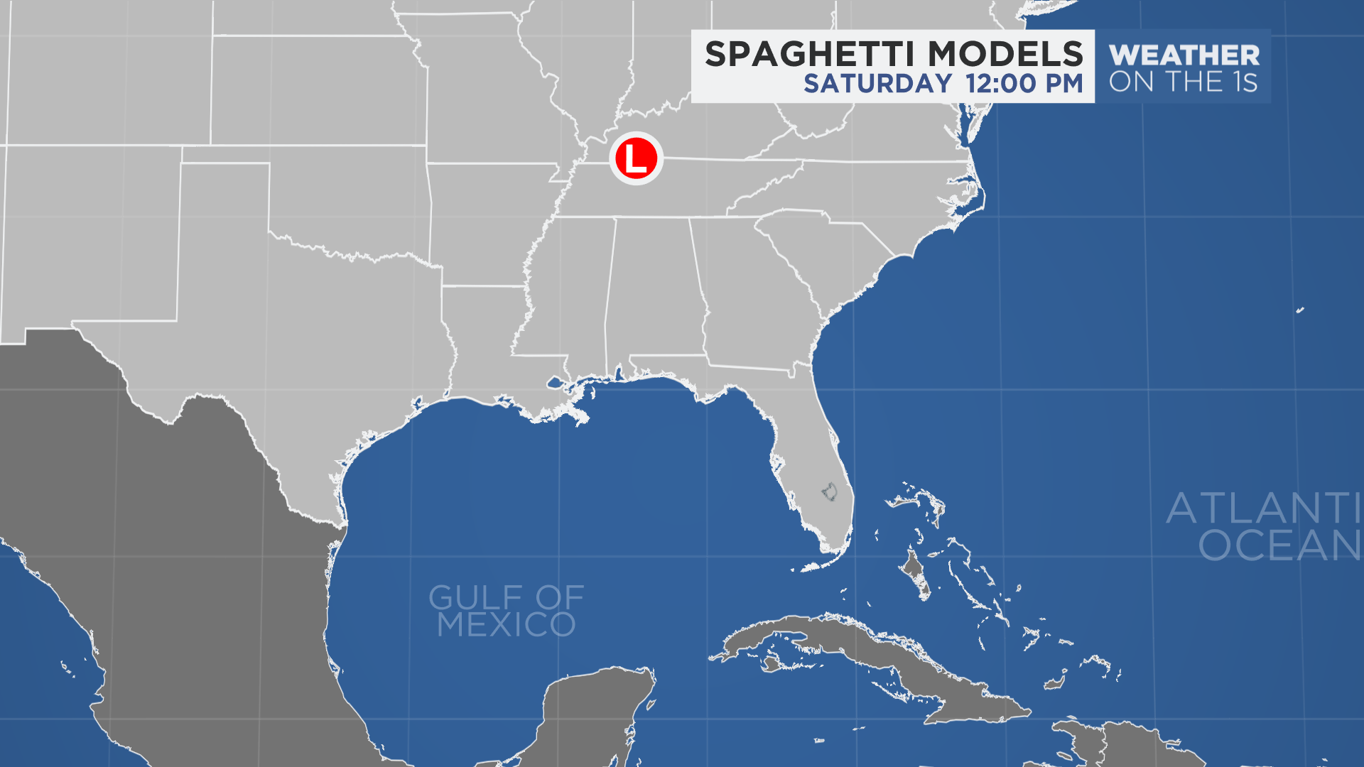
Spaghetti models or plots show a series of individual computer forecast models together on one map. They are useful to give insight into whether multiple models are in agreement on the path of the storm but they do not address the storm’s forecast intensity, winds, flooding and storm surge potential or other data. Tap here for more details on how to best use these models.
Elsewhere in the Atlantic, there is one other disturbance with potential to develop.
See how the 2022 Atlantic hurricane season has gone so far.