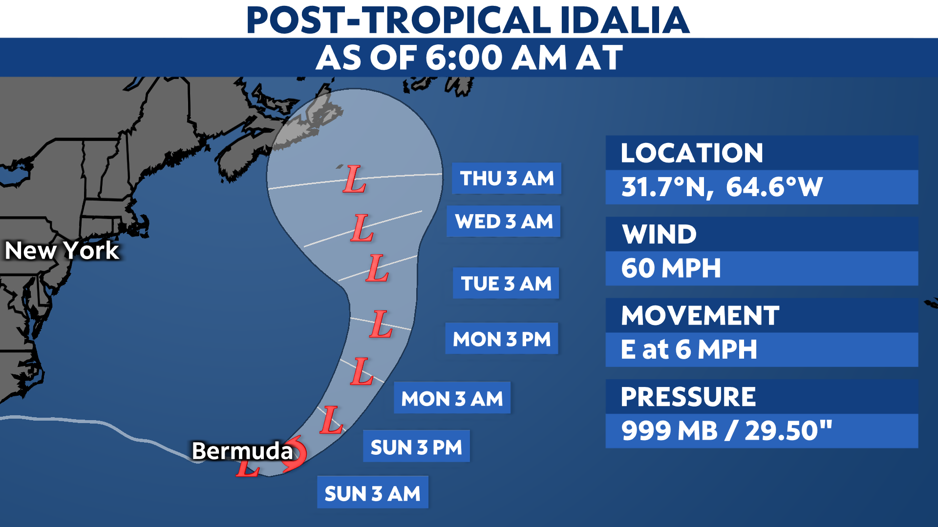
Idalia turned post-tropical Thursday evening after moving offshore from the Carolinas. It’s heading southeast and will bring tropical storm conditions to Bermuda this weekend.
Over 100,000 customers across the Southeast are still without power, according to PowerOutage.us.
Although Idalia has turned post-tropical, it’s expected to regain tropical characteristics again this weekend. The storm is moving away from the U.S. and is near Bermuda, where a Tropical Storm Warning is in place. Heavy rainfall there could lead to flooding.
Idalia will also keep generating swells that send rough surf and a threat of rip currents to the East Coast.
Idalia’s history
Idalia first formed in the Caribbean Sea on Aug. 27 and stalled near the tip of the Yucatán Peninsula. It then moved north into the Gulf of Mexico, where it rapidly intensified to a Category 4 hurricane.
Idalia weakened slightly just before landfall, but struck as a major Category 3 hurricane near Keaton Beach, Fla. around 7:45 a.m. on Aug. 30, with top estimated wind speeds of 125 mph.
According to the National Weather Service in Tallahassee, no major hurricanes since records began in 1851 had tracked into Apalachee Bay. A landfall there is unprecedented in modern times.
Idalia brought destructive storm surge and winds to parts of Florida’s Gulf Coast, especially in the Big Bend region and northern reaches of the Nature Coast. Perry, Fla. reported an 85 mph wind gust, and Horseshoe Beach hit 81 mph. At one point, about a half-million customers in Florida and Georgia had no electricity.
The worst storm surge issues were on Florida’s Gulf Coast, especially in the Big Bend region. Here is a time lapse from Steinhatchee, Fla. as Idalia made landfall on the morning of Aug. 30, 2023.
The water level at Cedar Key, about 50 miles from the landfall point, had a storm surge of nearly 7 feet. Homes in Horseshoe Beach, Fla. had water marks six feet up the walls, and one resident estimated at least 50 homes were destroyed.
Storm surge inundated parts of the Tampa Bay area. Water was at least a few feet deep in surge-prone parts of Pinellas County Tuesday, closing numerous roadways. You can see a gallery of damage photos from the Tampa region.
On the Atlantic coast, the high tide during the evening on Aug. 30 in Charleston, S.C. surpassed 9.2 feet, its fifth-highest reading since records began there in 1899.
Idalia also dropped heavy rain that caused inland flooding. Some locations in Florida, Georgia and the Carolinas got more than 9 inches of rainfall. Mullins, N.C. reported nearly a foot of rain Thursday morning. Floodwater entered buildings in downtown Whiteville, N.C.
Officials reported one death in Georgia and another in Florida.
Check here for a look at the 2023 Atlantic hurricane season so far.
The Associated Press contributed to this story.
Our team of meteorologists dives deep into the science of weather and breaks down timely weather data and information. To view more weather and climate stories, check out our weather blogs section.