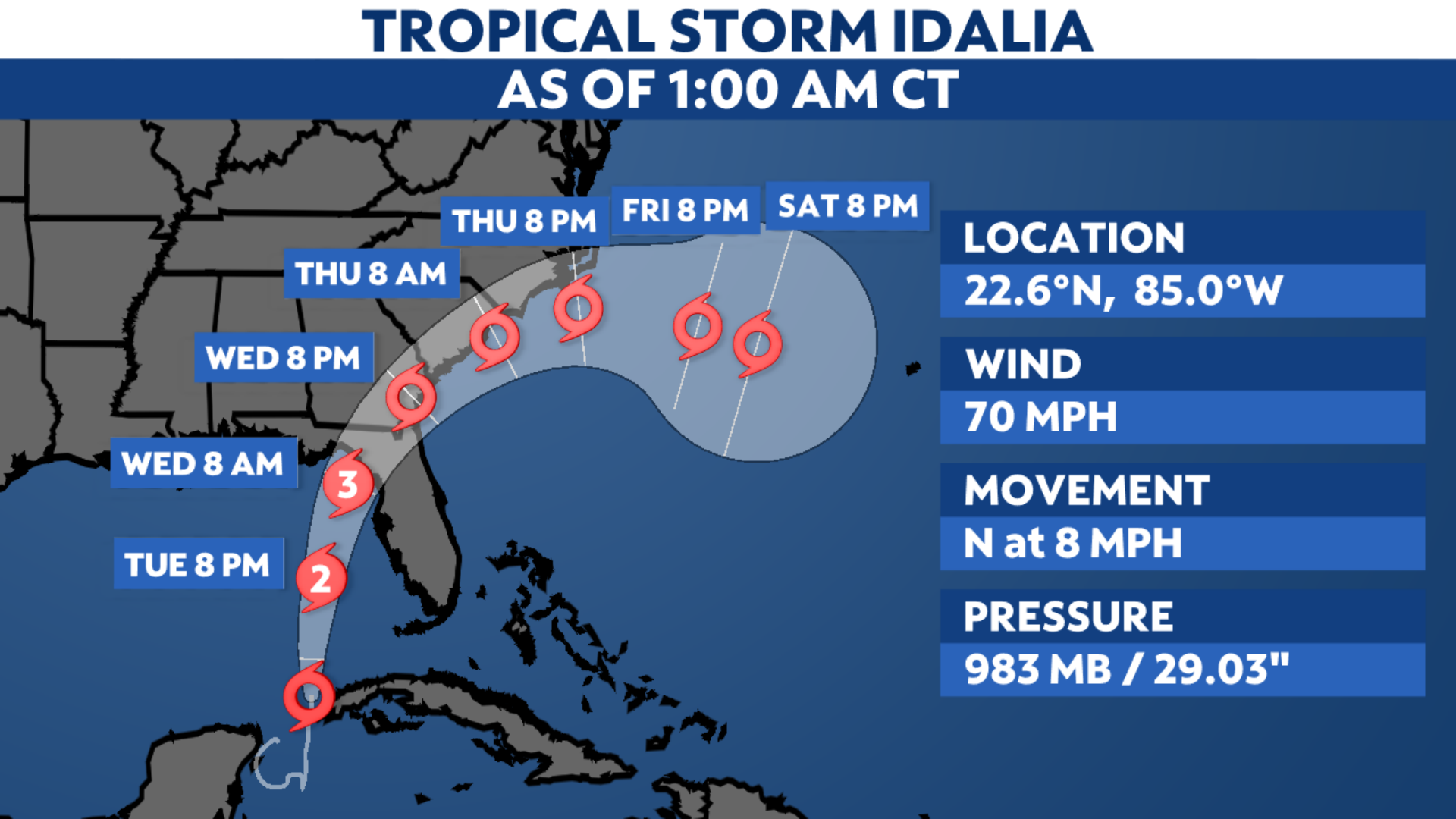
After forming off the Yucatan Peninsula on Sunday, Idalia remains a tropical storm. It continues to strengthen and will become a hurricane soon. It is expected to become a major hurricane in the eastern Gulf of Mexico prior to making landfall in Florida on Wednesday.
Hurricane and Storm Surge Warnings are now in effect along northern and central portions of the Florida Gulf Coast, including Tampa Bay.
Florida Gov. Ron DeSantis declared a state of emergency for 46 counties to prepare for the expected tropical system.
The storm is located near the western tip of Cuba, producing top sustained wind speeds of 70 mph. It will continue to head north, where it will become a hurricane as it moves toward the eastern Gulf of Mexico.
Favorable environmental conditions will fuel its intensification in the next few days, allowing Idalia to become a major hurricane after it emerges over the warm waters of the Gulf.
The exact path and landfall location remain uncertain, although trends have been focusing on Florida’s Nature Coast. The potential for Idalia to make landfall along the northern Gulf Coast of Florida as a major hurricane is likely.
Computer forecast model guidance agrees that it will affect other parts of the Southeast this week, as well.
Spaghetti models show it tracking up from Florida to the Carolinas. Reconnaissance flights are investigating this system, giving a better idea of what’s happening and helping computer forecasts get more data to clarify what may come.

Spaghetti models or plots show a series of individual computer forecast models together on one map. They are useful to give insight into whether multiple models are in agreement on the path of the storm, but they do not address the storm’s forecast intensity, winds, flooding and storm surge potential or other data. Tap here for more details on how to best use these models.
Hurricane Warnings are now in effect along the Florida Gulf Coast, from the Middle of Longboat Key to Indian Pass, including Tampa Bay. Pinar del Rio, Cuba, also remains under a Hurricane Warning as well.
Hurricane Watches issued for parts of the Florida Gulf Coast from Englewood to the Middle of Longboat Key.
Tropical Storm Warnings have been issued for the Dry Tortugas, and Chokoloskee northward to the middle of Longboat Key, west of Indian Pass to Mexico Beach and from Sebastian Inlet to Altamaha Sound in Georgia.
Tropical Storm Watches have been issued for the Lower Florida Keys west of the west end of the Seven Mile Bridge and Altamaha Sound northward to South Santee River in South Carolina.

Rainfall
Heavy rainfall and flash flooding will be possible across the Southeast later this week as Idalia moves inland. The highest rainfall totals are forecast to stretch from the Florida Panhandle through the Carolinas.
We talked to Spectrum News Bay News 9 meteorologist Diane Kacmarik on Saturday about the rainfall expectations in Florida.
“Rain totals will be sharply different from east to west. The highest totals will be along the west coast of Florida, inland areas will have less,” said Kacmarik.

Rainfall totals are forecast to exceed 6 inches across a large swath of the Southeast U.S., with locally higher amounts up to a foot possible. Eastern North Carolina could be one area that gets very heavy rain.
Storm surge
Storm surge will also be a threat to areas along Florida’s Gulf Coast. Bay News 9 Meteorologist Juli Marquez states that, “astronomical tides will be high with a full moon, so storm surge will be more impactful.”
Storm Surge Warnings are now in effect for from Englewood northward to Indian Pass, including Tampa Bay.
Storm Surge Watches are also in effect for the Florida Gulf Coast from Chokoloskee to Englewood and the mouth of the St. Marys River to South Santee River in South Carolina..
Marquez also adds that storm surge could be 4 to 7 feet for the Tampa Bay area, but could be as high as 8 to 12 feet for the Nature Coast. Other places, like Pasco County, could see between 6 to 9 feet of inundation.
Here is the latest storm surge forecast from Spectrum Bay News 9.

Along with the possibility of hurricane-force winds and all the other impacts mentioned above, Idalia could also spin up tornadoes as the storm tracks over the Southeast.
Check here for a look at the 2023 Atlantic hurricane season so far.
Our team of meteorologists dives deep into the science of weather and breaks down timely weather data and information. To view more weather and climate stories, check out our weather blogs section.