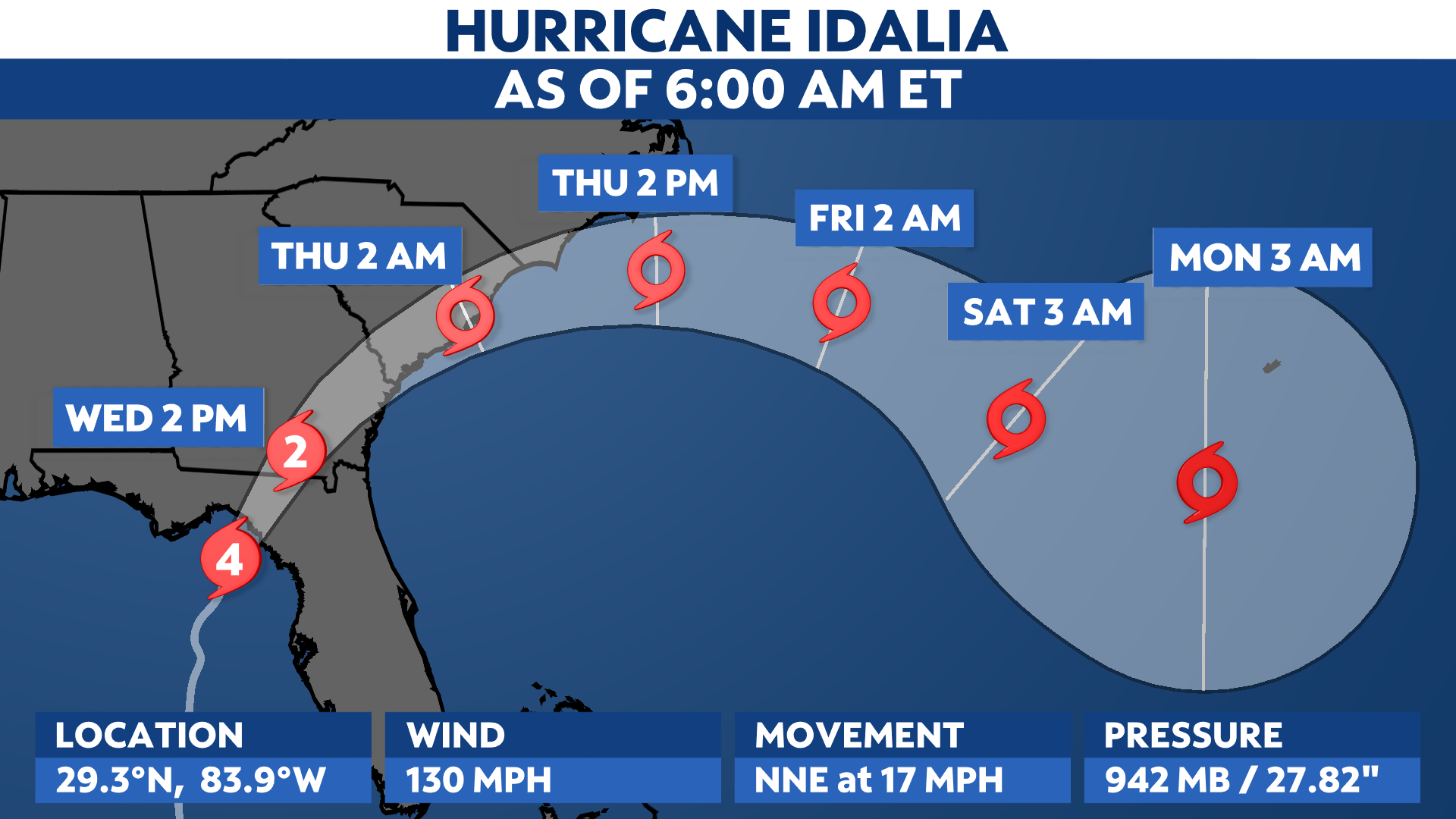
After becoming a major hurricane early Wednesday morning, Idalia continues to intensify. It is now a Category 4 hurricane and is forecast to remain a dangerous storm upon making landfall in the Big Bend of Florida on Wednesday.
Idalia is set to bring catastrophic storm surge and winds to parts of Florida’s northern Gulf Coast.
Dozens of counties are in a state of emergency to prepare for the hurricane and some airports are suspending operations until the threat passes.
Sitting about 55 miles west-northwest of Cedar Key, Idalia is producing maximum sustained wind speeds of 130 mph. It will continue to head toward the north-northeast, where favorable environmental conditions over the Gulf of Mexico will help it strengthen through Wednesday morning.
Trends have been focusing on a strengthening storm making landfall on Florida’s Big Bend or northern part of the Nature Coast.
According to the National Weather Service in Tallahassee, no major hurricanes since records began in 1851 have tracked into Apalachee Bay. A landfall there would be unprecedented in modern times.
Computer forecast model guidance agrees that it will also affect other parts of the Southeast this week.
Spaghetti models show it tracking up from Florida to the Carolinas.

Spaghetti models or plots show a series of individual computer forecast models together on one map. They are useful to give insight into whether multiple models are in agreement on the path of the storm, but they do not address the storm’s forecast intensity, winds, flooding and storm surge potential or other data. Tap here for more details on how to best use these models.
Hurricane Warnings and Tropical Storm Warnings are in effect up and down Florida’s west coast, and extend into parts of southern and central Georgia.
On Florida’s east coast, Tropical Storm Warnings are in effect.

Hurricane Watches are in effect for along and near the Georgia coast and extend into parts of the southeastern South Carolina, too.
Otherwise, Tropical Storm Watches and Warnings extend northward through parts of Georgia and into the Carolinas.

Storm surge
Storm surge will also be a threat to areas along Florida’s Gulf Coast. Bay News 9 Meteorologist Juli Marquez states that, “astronomical tides will be high with a full moon, so storm surge will be more impactful.”
Storm Surge Warnings are in effect from Englewood northward to Indian Pass, including Tampa Bay.
Storm Surge Watches are also in effect for the Florida Gulf Coast from Chokoloskee to Englewood and the mouth of the St. Mary’s River to South Santee River in South Carolina.
The most significant storm surge is expected toward the Big Bend region. If it happens near high tide, storm surge could reach above 12 to 16 feet above ground level. This is comparable to what happened during Hurricane Ian in the Fort Myers area.

Storm surge has already begun to move inland around the Tampa Bay Area. There have been reports of a few feet of water on the ground in Pinellas County early on Tuesday morning.
Rainfall
Heavy rainfall and flash flooding will be possible across Florida and the Southeast as Idalia moves inland. The highest rainfall totals are forecast to stretch from the Florida Panhandle and western coast through the Carolinas. Totals in some areas ought to exceed 6 inches.
As a result, Flood Watches are in place.

Along with the possibility of hurricane-force winds and all the other impacts mentioned above, Idalia could also spin up tornadoes as the storm tracks over the Southeast.
Tornado Watches remain in effect across a good portion of Central Florida and the Gulf Coast.
Check here for a look at the 2023 Atlantic hurricane season so far.
Our team of meteorologists dives deep into the science of weather and breaks down timely weather data and information. To view more weather and climate stories, check out our weather blogs section.