After Tropical Storm Isaias brought heavy rain and gusty winds to much of Florida on Sunday, the storm is now set to zip north and bring the potential for coastal flooding, heavy rain and gusty winds for much of the Eastern Seaboard early this week.
Hurricane watches are also now in place for parts of coastal North and South Carolina, as the storm could re-strengthen into a hurricane before an anticipated landfall there late Monday into early Tuesday.
While Isaias brought generally minor impacts to Florida in a glancing blow on Sunday, the storm could re-strenghten into a hurricane and deliver more widespread and direct impacts, starting on Monday night along the Carolina coastline.
“This will remain a small storm compared to the large hurricanes we’ve seen the past few years,” Spectrum News meteorologist Brian McClure said on Sunday. “With the storm moving fast through North Carolina, there won’t be a threat of lingering flooding rains or lingering storm surge. Instead, this will be a brief passing and then gone by Tuesday night.”
The storm will then move north right along the Eastern Seaboard, bringing the threat of heavy rain, gusty winds and coastal flooding to the much of the mid-Atlantic and New England coastline.
Though the storm will be moving briskly, it could deliver a meaningful burst of rain, wind and storm surge to parts of the East Coast. Isaias could also re-strengthen into a hurricane before a late Monday landfall on the Carolinas.
Even as a tropical storm, locally heavy rain and gusty winds will occur along the east coast of Florida. Through Sunday afternoon, top wind gusts were near tropical storm levels from Boca Raton to Port St. Lucie.
Storm surge of two-to-four feet is also possible, mainly from Jupiter Inlet to Ponte Vedra Beach.

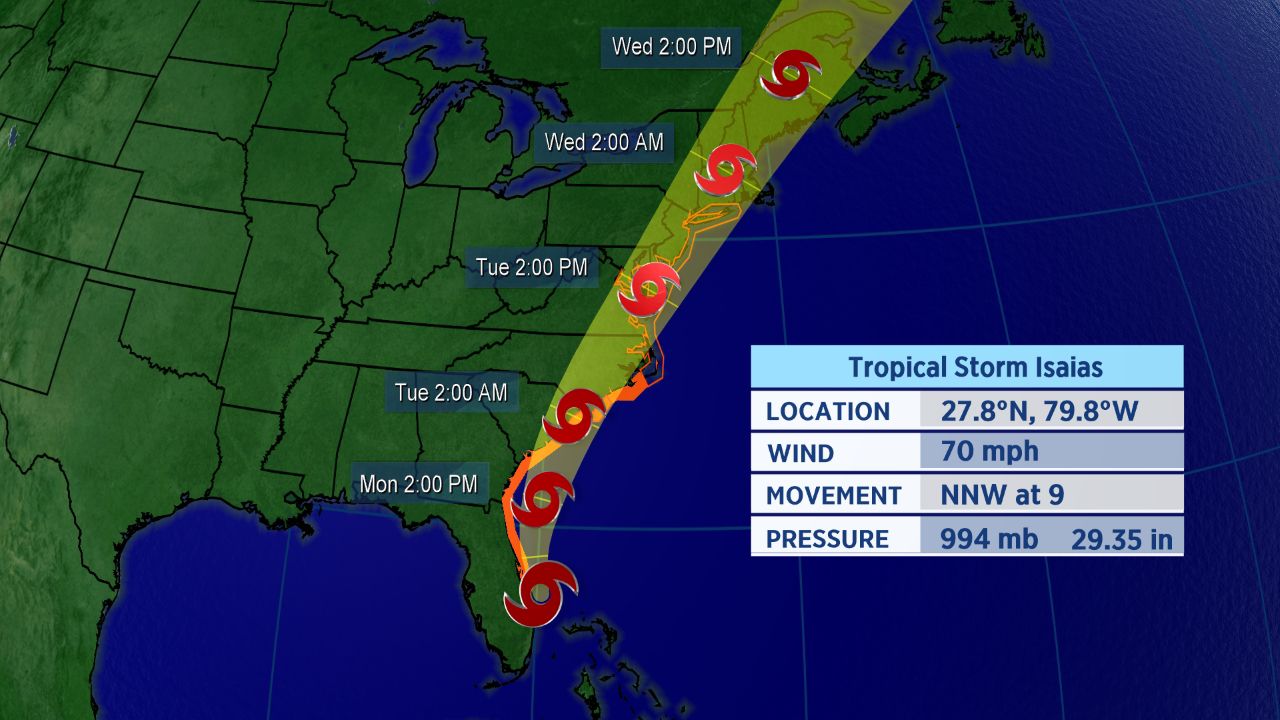
Forecast track of Tropical Storm Isaias.
Isaias is turning northward, skirting the Florida coast as it does so. As it rounds around a weak ridge in the Atlantic, it’ll gradually turn to the northeast in a couple of days.
Tropical storm warnings run from Sebastian Inlet, Florida to Ocracoke Inlet, North Carolina. A tropical storm watch extends north to Watch Hill, Rhode Island, including the entire mid-Atlantic coastline and much of southern New England’s.
Storm surge warnings have also been added for areas from Edisto Beach, South Carolina to Cape Fear, North Carolina.
For now, the center of the forecast cone of uncertainty takes Isaias up the east coast of Florida. The Carolinas should see impacts early in the week.
Extent of Impacts Depends on Track
Isaias has been on a steady west-northwestward to northwestward track, but that will change through the next couple of days. One bit of good news, with this particular storm, though: it’s small in size, which could limit the scope of its impacts.
Another positive with the storm is its anticipated forward speed, which could exceed 25 mph by Tuesday. That should limit the duration of the storm’s impacts.
However, even though Isaias is no longer a hurricane, it will still cause the potential for significant issues as it runs northward.
Impacts for mid-Atlantic and Northeast are also possible on Tuesday and Wednesday of next week.
“I expect the worst conditions along the North Carolina coast to occur late Monday through Tuesday morning,” Spectrum News meteorologist Matthew East said. “A few feet of storm surge looks likely in some areas, dependent on exactly where the center tracks.”
Isaias officially became the ninth-named storm of the Atlantic season and the earliest I-named storm on record. The previous record for the earliest ninth storm of the season was Irene, which formed on August 7, 2005.
The storm brought heavy rain and flooding, along with wind damage, to parts of the Caribbean. Hurricane warnings for the northwestern Bahamas were dropped Sunday morning as the storm moved away.
Isaias was the second hurricane of a busy to-date 2020 Atlantic season.
If you’re wondering how exactly Isaias is pronounced, here’s a detailed guide on how to properly say it (along with all the other 2020 Atlantic storms. In short, Isaias pronounced over four syllables: ees-ah-EE-ahs.
Keep checking in for the latest updates.