CLEVELAND — The National Weather Service now says at least nine tornadoes struck northern Ohio as severe storms moved across the state late Thursday night into early Friday.
Meteorologists with the National Weather Service in Cleveland said a tornado formed three miles northeast of Cleveland just before midnight.
NWS said it’s the first tornado to hit within city limits since 1985.
The weather service storm survey said the 150-yard wide tornado formed near East 71st Street and Chester Avenue and stayed on the ground for just three minutes.
The tornado lifted less than a mile away near East 89th Street and Euclid Avenue.
The tornado was ranked an EF-1 tornado on the Enhanced Fujita Scale with winds of 110 mph. The scale is used to rank the strength of a tornado by analyzing wind speeds and storm damage.
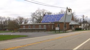
Officials said the tornado caused extensive tree damage and minor damage to homes. Calvary Church, located along Euclid Avenue in East Cleveland, received extensive roof damage. The storm survey also highlighted light poles bent near the base in a shopping center on East 79th Street and at the intersection of East 89th and Euclid Avenue.
New Life At Calvary church in Cleveland, which had its roof ripped off by an EF-1 tornado late Thursday night. (Spectrum News 1/Jenna Jordan)
Just to the northeast in Mentor, meteorologists said damage there was caused by an EF-1 tornado. That twister, with winds of 110 mph, first touched down west of Dartmoor Road near Mentor Avenue where large trees were downed. Meteorologists said the tornado tracked east, knocking down large trees. Several homes on Stockbridge Road and Middlesex Road were damaged when trees fell on them.
The tornado continued to the east, across the Great Lakes Mall property, before it shifted northeast and caused tree and power line damage near the intersection of Johnnycake Ridge Road and Fairview Avenue. The tornado lifted just south of Donald E. Kruger Park.
A third EF-1 tornado hit between Sandusky and Ottawa counties. It started near South Nissen Road and West Deno Road, then continued southeast, crossing the Portage River.
Officials said the tornado had max winds of 110 mph and uprooted three trees onto a home, leaving a damaged roof. It also downed several other trees, damaged the siding of another home and snapped power lines along County Road 92.
This tornado stayed on the ground for about 17 minutes, traveling 4.29 miles, according to the NWS. Its maximum path width was 100 yards.
A fourth tornado touched down in Bristolville in Trumbull County and stayed on the ground for two minutes. The EF-0 tornado had a max wind speed of 85 mph and traveled nearly 3 miles.
It started east of Mahan Denman Road, eventually crossing Thompson Clark Road. Multiple homes sustained minor damage, and one home had a car port collapse, the NWS said. The tornado continued heading east and ended near North Park Avenue.
The fifth tornado was an EF-1 in Lake County. The tornado touched down in Berlin Heights. NWS said it uprooted trees and caused several limbs to fall on homes, destroying at least one. The tornado traveled southeast into a rural area, where it ended.
The sixth tornado touched down in Spencer in Medina County shortly after midnight. The EF-1 tornado had a max wind speed of 90 mph and stayed on the ground for about two minutes, tracking 1.56 miles.
The tornado started near Hunter Road, then moved southeast into the south side of Spencer. NWS said many trees were uprooted and one house had minor damage to its shingles.
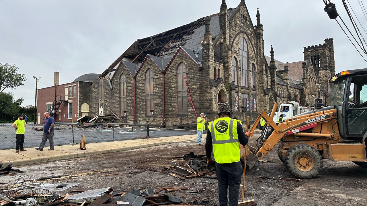
The seventh tornado confirmed was an EF-2 that hit Warrensville Heights and Bedford Heights, according to the NWS. It had a max wind speed of 120 mph and stayed on the ground for two minutes.
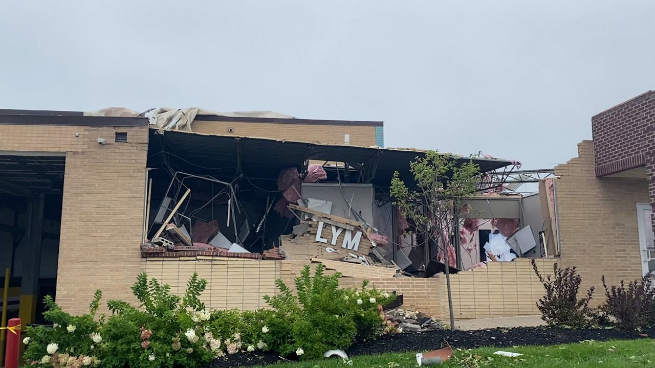
Damage to the Lyman Steel building. (Spectrum News 1/Katie Priefer)
The NWS said it began near Vera Street and then tracked southeast across the main interchange of I-271 and I-480. NWS said it emerged across Galaxy Parkway and continued southeast. The tornado took down trees, damaged a car dealership, uprooted a tree onto a home on Springfield Road and caused significant damage to two industrial buildings. Large trees also fell on a home just east of Highway 422.
Tornado No. 8 hit southeast of Chardon in Geauga County and was rated EF-1. The tornado began near the intersection of Aquilla Road and Tewksbury Lane and lifted on the east side of Taylor Wells Road.
The ninth tornado was also in Geauga County in Middlefield and was rated EF-2. It stayed on the ground for a minute, but caused destruction. It started near the intersection of Burton-Windsor Road and Route 608, then it tracked southeast, completely destroying a barn. NWS said the entire barn was lofted and thrown about 150 yards. The outer structure, which was composed of cinder blocks, collapsed. The tornado lifted at the intersection of Route 608 and Nauvoo Road.
More than 60,000 remain without power following Thursday’s night’s severe weather, the majority being in the Cleveland area. As of Saturday afternoon, no serious injuries had been reported.