Despite some challenges in the forecast, one thing is certain. A significant storm system will affect much of the Ohio Valley and the eastern U.S. starting tonight.
Some location-specific details still remain a bit unclear, but the latest models seem to be in better alignment with one another in terms of timing and track.
Knowing the storm’s track is key, especially for predicting where the rain-snow line sets up and determining who gets what.
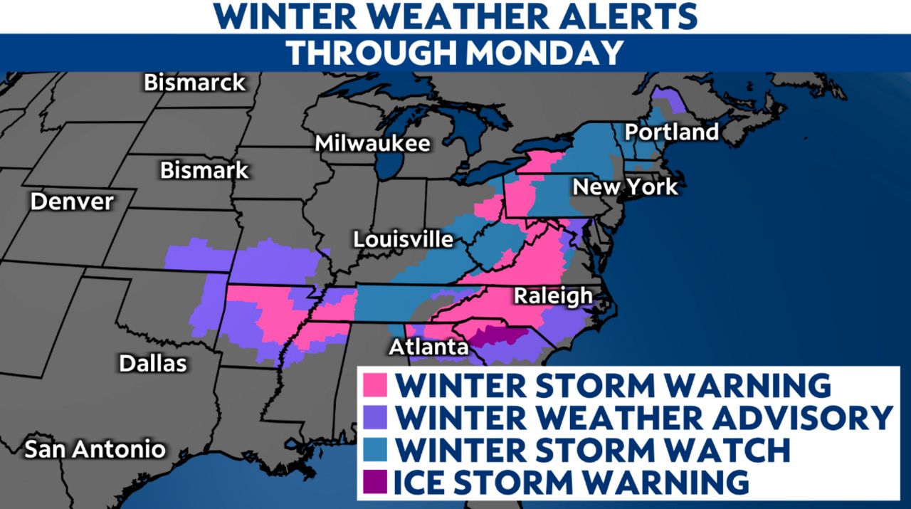
Overall, there’s a better consensus on this storm’s path. However, any slight shift in track could change whether or not an area sees snow and if so, how much. But for now, we have winter weather alerts scattered across the eastern U.S.

While this storm will bring snow and a wintry mix to some, it will bring heavy rain and the possibility of some severe storms to others. Additionally, it will also be responsible for generating powerful winds, the potential for widespread power outages and even coastal flooding, as well.
What we know
The weather system will dive into the Southeast today, then ride up near the East Coast Sunday into Monday.
Temperatures will be cold enough to support areas of snow, with a wintry mix in the transition area to rain. Wintry precipitation will affect parts of the Carolinas, the Ohio Valley and the Northeast.
Where freezing rain happens, ice accumulations could be enough to cause power outages.
On the eastern, warmer side of the system, precipitation will be mostly, if not completely, rain.
See the differences
It’s still too far out to know where exactly the system tracks. Until then, confident and accurate predictions of precipitation amounts are impossible. For quite a few areas, even knowing the type of precipitation is a big question mark, let alone how much will fall.
Meteorologists look at a lot of different information, but we’ll share images from two of the main global forecasting models.
These first two are what they’re predicting for 5 p.m. Sunday evening, as of Saturday.
Cloud and precipitation forecast from the European computer model Sunday evening.
Cloud and precipitation forecast from the American computer model Sunday evening.
The next two are for noon on Monday, which is Martin Luther King Jr. Day.
Cloud and precipitation forecast from the European computer model midday Monday.
Cloud and precipitation forecast from the American computer model midday Monday.
They both show a noteworthy nor’easter, but with different tracks and impacts. In the end, neither of them will be exactly right, but this shows just how much local impacts will depend on where the system ends up going.
So, what should I do?
Keep checking your local forecast for updates, and don’t buy into social media hype.
If you have plans for Sunday or Monday–depending on when it arrives where you live–you may want to start thinking about shifting them as the situation becomes clearer.
Since this will happen on a Sunday into a holiday when schools and a number of workplaces will close, whatever the system brings won’t have as big of an impact on people traveling.