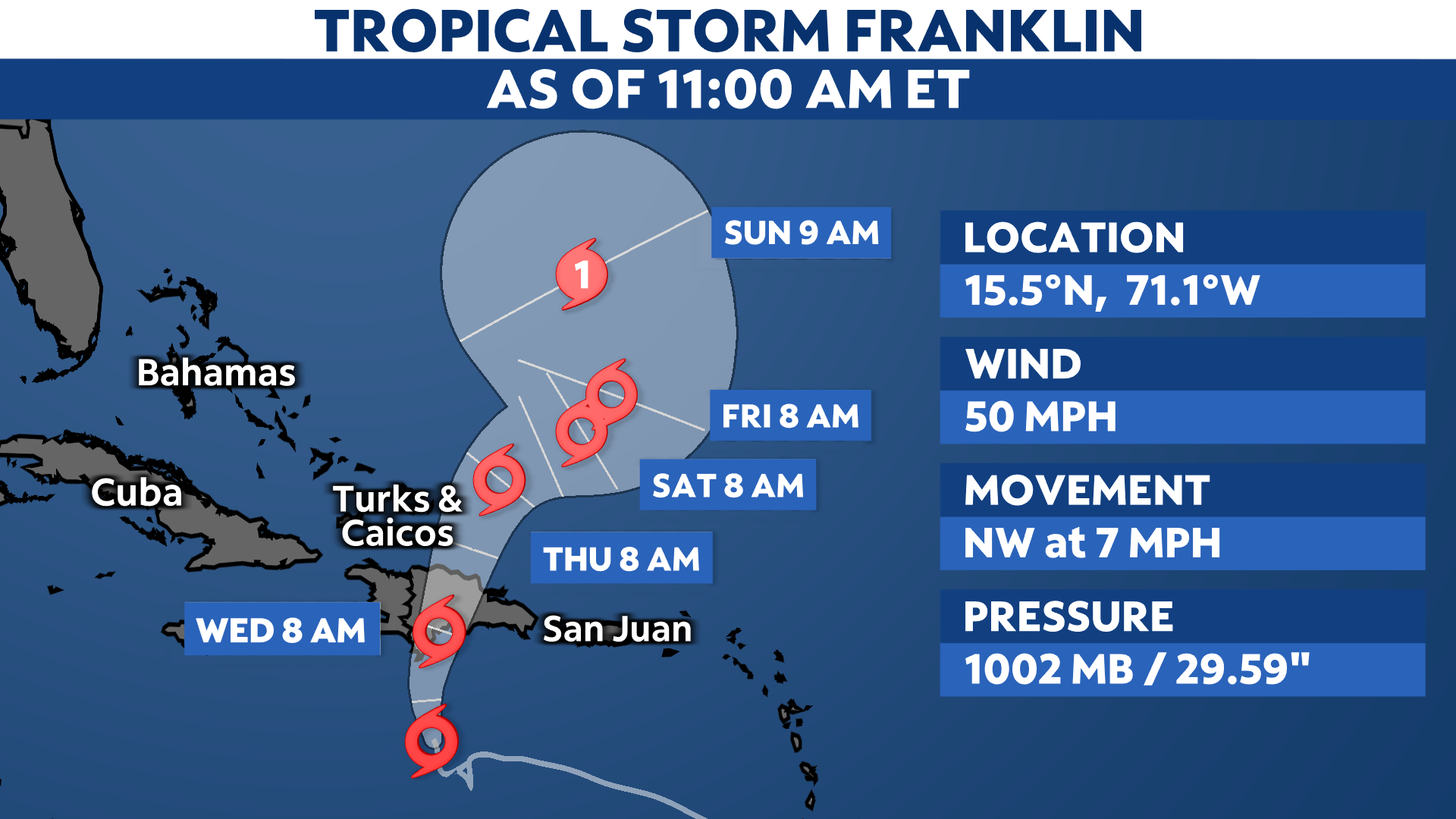
Franklin is a tropical storm over the Caribbean Sea, although is disorganized for now. It’s moving north-northwest, about 220 miles south of Santo Domingo in the Dominican Republic.
Franklin formed on Sunday, Aug. 20, becoming the sixth named storm of the 2023 Atlantic hurricane season. Even though it is still drifting toward the northwest, Franklin is forecast to take a more northerly path starting Tuesday evening.
Despite not much change in strength since developing, Franklin is still producing maximum sustained winds of 50 mph. While still a poorly defined storm, it could gain a little intensity before moving over Hispaniola on Wednesday.

Franklin is expected to bring tropical storm conditions to the Dominican Republic, Haiti and the Turks and Caicos midweek before it pivots toward the northeast late Thursday into Friday.
Tropical Storm Warnings are now in effect along the southern coastline of Hispaniola, with Tropical Storm Watches in effect for the island’s northern shores and for the Turks and Caicos.

Parts of Hispaniola will see the heaviest precipitation from Franklin, with southern portions of the Dominican Republic receiving anywhere between 5 to 10 inches of rain. Some select places could see rainfall totals add up to over a foot.
Even though the center of Franklin will move over the Dominican Republic or Haiti, its outer bands will still likely clip Puerto Rico, bringing the island heavy rainfall and gusty winds, as well.
While no tropical alerts have been issued for Puerto Rico, widespread rainfall totals between 1 to 3 inches are possible through Thursday, with locally higher amounts reaching up to 6 inches in spots.

In addition to powerful winds and rain, Franklin will also generate large swells and dangerous rip currents, especially along the southern shores of Hispaniola prior to making landfall later on Tuesday.
Once Franklin moves over Hispaniola, it then will curve toward the northeast later this week before redirecting itself back north again. Once over the open waters of the Atlantic this weekend, Franklin become a hurricane.
We’re currently monitoring a couple other areas with the potential to develop across the Atlantic basin, along with Tropical Storm Harold.
Check here for a look at the 2023 Atlantic hurricane season so far.
Our team of meteorologists dives deep into the science of weather and breaks down timely weather data and information. To view more weather and climate stories, check out our weather blogs section.