After a bitterly cold weekend, a nice and well-deserved warm-up will be taking shape across Ohio for the first few days of the week.
What You Need To Know
- Expect a quiet start to the week
- Highs will be in the 40s and 50s Tuesday
- A powerful front brings rain to Ohio Wednesday
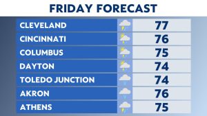
- Rain will mix with, and change to snow and ice Thursday into Friday
With an increase in southerly winds, Monday will start off with mixed skies and cold, but seasonable temperatures. Expect mostly sunny skies by the afternoon with highs on par with where they should be this time of year.
However, increasing clouds and winds on Tuesday will signal a shift to move active weather by the middle of the week.
With gusty south winds ahead of our next front, Tuesday’s high temperatures should reach the low and even middle 50s in parts of the state. Rain will move in west to east late Tuesday night.
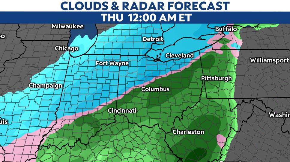
A powerful front will grab moisture from the south and transport it here, increasing the intensity and coverage area of the rain by Wednesday morning.
As that happens, colder air will begin filtering in, changing rain to a wintry mix- and by Thursday, to snow.

The question of when this all occurs is going to be the big one.
As it stands now, areas along and north of I-70 have the best chance of seeing ice and accumulating snow. That said, the entire state of Ohio should prepare now for a messy, and possibly dangerous commute Wednesday morning all the way through Friday morning.
The entire Spectrum News 1 weather team is watching this and will provide fresh updates through the rest of the weekend and into next week.