
Hurricane Ida made landfall in Louisiana on Sunday as a Category 4 storm, battering the coast and threatening destruction in New Orleans as the storm stands to be one of the most devastating to strike the city since Hurricane Katrina.
The storm’s maximum sustained winds on Sunday morning reached 150 miles an hour, closing in on the 157 m.p.h. winds of a Category 5 storm. In New Orleans and across southeast Louisiana, residents were bracing themselves for the worst of the hurricane.
“This is a major, major storm that is going to test us in ways that we have not been tested before,” Gov. John Bel Edwards of Louisiana said on CBS’s “Face the Nation” on Sunday.
The storm has New Orleans directly in its path. On the city’s streets Sunday morning, the wind whipped in fearsome gusts as strong as 70 miles an hour. There were few cars in motion, except for the occasional howling emergency vehicle. Downtown, a few homeless people tucked themselves into the porticos of buildings. But the people who remained in New Orleans had mostly hidden themselves away.
“This is the time to stay inside,” Mayor LaToya Cantrell said in a late morning news conference. “Do not venture out. No sightseeing.”
The storm could also wreak serious havoc farther inland, in places like greater Baton Rouge, where a number of areas have been devastated by inland flooding in recent years from much less powerful storms.
Hurricane Ida will bring “extremely threatening storm surge inundation of 9 feet or higher” between Burns Point, La., and Ocean Springs, Miss., the Hurricane Center warned.
In some places the surge could be as high as 16 feet. Catastrophic wind gusts and inland flooding from rain are also expected. Power outages were already being reported across southern Louisiana.
Governor Edwards described Ida’s potential impact as historic. “We can sum it up by saying this will be one of the strongest hurricanes to hit anywhere in Louisiana since at least the 1850s,” he said on Saturday.
The storm made landfall on the 16th anniversary of the landfall of Hurricane Katrina, stirring painful reminders of the death and devastation that the 2005 storm wrought, leaving psychological scars that still run deep in the city. The storm killed 1,833 people, inflicted more than $100 billion in damage, and submerged large stretches of New Orleans, leading to scenes of suffering that horrified the nation.
“It’s definitely triggering to even have to think about this,” said Victor Pizarro, a health advocate and a resident of New Orleans who planned to ride out the storm with his husband in the Gentilly Terrace neighborhood. “It’s exhausting to be a New Orleanian and a Louisianian at this point.”
The trajectory and strength of Ida will present a high-stakes test of the levees, flood walls, pumps and gates that were reinforced around New Orleans after Katrina.
But there was also another urgent concern: The storm threatened to strain hospitals, already under pressure from patients sick with the coronavirus. Louisiana is in the throes of one of the worst coronavirus outbreaks in the nation, with nearly as many people hospitalized with Covid-19 statewide as in any earlier period of the pandemic.
In television appearances on Sunday, Mr. Edwards said that the pandemic had thwarted plans to evacuate hospitals.
“Evacuating these large hospitals is not an option because there are not any other hospitals with the capacity to take them,” he said on “Face the Nation.” “We were able to evacuate over 20 nursing homes and rehab facilities and behavioral facilities and those sorts of things. But when you think in terms of hospitals, it is just not possible.”
transcript
transcript
Louisiana Braces for Hurricane Ida
Louisiana residents rushed to evacuate or hunkered down with supplies ahead of Hurricane Ida. The Category 4 storm is one of the most powerful systems to hit the region since Hurricane Katrina, bringing life-threatening storm surge and winds.
-
We’ve decided to take off. Yeah, because just like with Hurricane Katrina, we’re not trying to be here for the disaster, so we are taking no chances. We’re leaving. Boarding up. We boarded up the two buildings across, I’ve been two days now boarding up a lot of buildings, a lot of buildings, getting ready, crossing our fingers. I went to Academy, and I bought a dozen life jackets just in case, you know. I hope I get to bring them back. I hope I don’t have to use them, but I’d rather have it and not need it than not have it and need it.

Officials believe hundreds of thousands of people have already evacuated the metropolitan area, but many people remained, sheltering in place.
The storm intensified quickly in large part because the water in the Gulf is very warm, and warmer water provides more energy to the storm. The Gulf is normally warm in late summer, but research over the past decade suggests that climate change also plays a role.
Studies have found that the oceans generally are warming as a result of human-caused emissions of greenhouse gases, making the rapid intensification of hurricanes occur more frequently. In Ida’s case, the storm strengthened to a Category 4 only an hour after it first reached Category 3.
More than 2,000 employees from the Federal Emergency Management Agency are deployed to Alabama, Florida, Georgia, Louisiana, Mississippi and Texas, the White House announced Sunday.
One hundred ambulances and emergency medical service providers are on call for post-storm evacuation support, and 13 urban search and rescue teams are deployed.
In Louisiana, the Red Cross, state officials and other community groups are planning to open dozens of shelters for at least 16,000 people.

As Hurricane Ida closed in on the Louisiana coast on Sunday morning, meteorologists were stunned to watch the storm strengthen so quickly.
When Dale Eck, the head of forecast operations for the Americas at IBM, went to bed on Saturday night, he said, Ida’s winds were blowing at 105 miles an hour, which is Category 2-level wind speed. The next morning, he saw the winds had increased to 150 m.p.h., strong enough for a Category 4 classification.
“I got a sinking feeling in my stomach,” he said. “That was one of the worst-case scenarios.”
The storm had evolved swiftly from a worrisome disturbance in the Atlantic Ocean to possibly the most devastating to strike Louisiana since Hurricane Katrina in 2005.
Before Ida became a named storm on Thursday, forecasters detected what they thought was just another cluster of thunderstorms, or a disturbance, moving west over the Atlantic, said Ben Gelber, a meteorologist at WCMH-TV in Columbus, Ohio.
It quickly became clear that this disturbance was unique, because it was hovering in an area where the wind wasn’t fast enough to carry the ocean’s heat away from the system, Mr. Eck said. That allowed the heat to stay inside the system, creating the perfect humid environment for the disturbance to intensify into a tropical storm.
“It would have been hard to concoct a path more favorable to this rapid strengthening than Ida’s,” said Robert Henson, an independent meteorologist and a journalist for Yale Climate Connections.
Ida reached Cuba on Friday as a Category 1 hurricane, the lowest of the five hurricane classifications. From there, forecasters knew the storm would be intense, and the only question was just how bad it would get.
From Saturday into Sunday, a cauldron of weather conditions made Ida a devastating Category 4 storm: Its winds accelerated rapidly to 150 m.p.h.; a ridge of high-pressure air off the Southeastern United States shepherded the storm toward Louisiana; and the waters in the Gulf of Mexico were unusually warm and very deep, meaning that there was a lot water Ida could churn up to sustain itself.
The fact that the water was still warm was reason to worry that the storm could continue to strengthen to a low Category 5, said Benjamin Schott, the meteorologist in charge for the National Weather Service in New Orleans.
On Twitter, meteorologists across the country expressed alarm at how quickly Ida evolved into a colossal threat.
“I desperately wish the forecast hadn’t become reality,” said Rick Knabb, a hurricane expert at the Weather Channel, adding that rapid intensification before landfall is “the hurricane scenario we’ve always dreaded.”
Eric Blake, a senior hurricane specialist at the National Hurricane Center, said: “I feel sick to my stomach watching this hurricane. This is a very sobering morning.”

NEW ORLEANS — As storm-force winds and rainfall reached the New Orleans area on Sunday morning, knocking out power in some places and making highway travel dangerous, it was already too late to leave. Still, some people in the city were second-guessing their decision to stay.
“I’m a little nervous,” said Le-Ann Williams, 30, as she cooked breakfast and watched the forecast in her New Orleans East apartment.
The roads west and east of New Orleans were parking lots for much of Saturday as tens of thousands of people tried to make their way out of the storm’s predicted path. It took Robert Green Sr. 16 hours to get to Houston from New Orleans on Saturday, ordinarily a five-hour drive.
At the same time, thousands more decided to stay put.
Shawn Kelly meant to leave. He does not have a car, so he booked a flight out. But by Saturday afternoon, he got a notification that the flight had been canceled, and social media posts showed hourslong lines at the airport.
So the stage was set: He’d try to ride out Hurricane Ida in his parents’ home in the Uptown area of New Orleans — the same place where he and his family tried to ride out Katrina in 2005, when he was 10 years old. Back then, the family wound up having to be rescued, a scenario he hopes won’t be repeated.
“I wish I could leave, because the next couple days without power are going to be the worst part,” Mr. Kelly said. “I’m worried about the aftermath, more so than the storm, because that was the thing with Katrina; it was the aftermath. I’m always worried about what comes after.”
For New Orleans leaders, the question is what will happen to those who stayed behind if Ida’s destruction makes conditions uninhabitable.
The answer is “post-storm evacuation,” said Collin Arnold, the city’s director of emergency preparedness. Urban search-and-rescue teams were prepared, and buses have been placed on high ground, ready to carry people out of town on Monday, once the storm blows through.
Older people in the city often talk proudly of never having evacuated, even in the face of serious storms like Hurricane Betsy in 1965. But Mr. Arnold said the plans for post-storm rescues were not an endorsement of that bravado, just an acknowledgment that fast-moving storms like Ida may leave little time for evacuation.
“We’re not intentionally choosing it,” he said. “It’s changes in the climate that are doing it to us.”
Evacuation is a crucial part of the disaster plan in a city where one in five households lack cars. But to be effective, the evacuation process should begin 72 hours before a storm hits. And Ida, a sprinter of a storm, was little more than a tropical disturbance in the Caribbean on Thursday afternoon, when Mayor LaToya Cantrell would have had to issue the order.
“Time was not on our side,” Ms. Cantrell said on Friday as she encouraged residents to voluntarily evacuate, but it was too late for a mandatory order.
Tens of thousands of people weighed their options and decided to hunker down. Some were optimistic that the city’s improved levees and pumps would hold this time. For others who had already paid their monthly bills, money was too short to travel now.
“Evacuation will always be the safest option for major hurricanes,” Mr. Arnold said. “Before Katrina, there were locals who would say, ‘I don’t leave for storms.’ Katrina changed that mind set. Now climate change may be changing it for us again.”
Katy Reckdahl and

Hurricane Ida’s landfall Sunday brought dangerous wind, storm surge and rain to the Gulf Coast exactly 16 years after the arrival of Hurricane Katrina, one of the most costly natural disasters in American history, which left more than 1,800 dead and did more than $100 billion in damage.
The overall impact of storm surge from Ida is predicted to be somewhat less severe than that from Katrina. The 2005 storm was blowing at Category 5 strength in the Gulf of Mexico before weakening as it approached landfall, so it generated enormous storm surge, reaching more than 20 feet in parts of the Mississippi coast. Current projections put the potential storm surge of Ida at 12 to 16 feet in the worst areas.
“Fifteen-foot sure can do a lot of damage,” said Barry Keim, a professor at Louisiana State University and Louisiana State Climatologist. “But it’s going to be nothing in comparison with Katrina’s surge.”
Improvements to the levee system following Katrina have made the New Orleans metro area better prepared for storm surge. But the areas that are likely to receive the most severe surge from Ida may be less equipped to handle it than the area that was hit by Katrina, said Dr. Keim.
Ida made landfall to the west of where Katrina struck, bringing the most severe storm surge to the Louisiana coast west of the Mississippi River rather than east of the river, as Katrina did.
“We are testing a different part of the flood protection in and around southeast Louisiana than we did in Katrina,” Dr. Keim said. “Some of the weak links in this area maybe haven’t been quite as exposed.”
While the impacts of Ida’s storm surge are expected to be less severe than Katrina’s, Ida’s winds and rain are predicted to exceed those that pummeled the Gulf Coast in 2005. Ida made landfall as a Category 4 storm with sustained winds around 150 miles an hour; Katrina came ashore as a Category 3 with winds of 125 m.p.h.
“It could be quite devastating — especially some of those high-rise buildings are just not rated to sustain that wind load,” said Jamie Rhome, acting deputy director of the National Hurricane Center.
The severe damage from Hurricane Laura, which struck southwest Louisiana last year as a Category 4 storm, was caused primarily by high winds. The storm caused 42 deaths and damage costing more than $19 billion.
Ida’s rainfall also threatens to exceed Katrina’s highs.
The National Hurricane Center estimates that Ida will drench the Gulf Coast with 8 to 16 inches of rain and perhaps as much as 20 inches in some places. Katrina brought 5 to 10 inches of rain, with more than 12 inches in some areas.
“That is a lot of rainfall,” Mr. Rhome said of the forecast for Ida. “Absolutely the flash flood potential in this case is high, very high.” Combined with storm surge, he said, that much rain could have a “huge and devastating impact to those local communities.”

Hurricane Ida intensified overnight, becoming a Category 4 storm over the course of just a few hours. The rapid increase in strength raises questions about how much climate change is affecting hurricanes in the Atlantic Ocean. While researchers can’t say for sure whether human-caused climate change will mean longer or more active hurricane seasons in the future, there is broad agreement on one thing: Global warming is changing storms.
Scientists say that unusually warm Atlantic surface temperatures have helped to increase storm activity. “It’s very likely that human-caused climate change contributed to that anomalously warm ocean,” said James P. Kossin, a climate scientist with the National Oceanic and Atmospheric Administration. “Climate change is making it more likely for hurricanes to behave in certain ways.”
Here are some of those ways.
1. Higher winds
There’s a solid scientific consensus that hurricanes are becoming more powerful.
Hurricanes are complex, but one of the key factors that determines how strong a given storm ultimately becomes is ocean surface temperature, because warmer water provides more of the energy that fuels storms.
“Potential intensity is going up,” said Kerry Emanuel, a professor of atmospheric science at the Massachusetts Institute of Technology. “We predicted it would go up 30 years ago, and the observations show it going up.”
Stronger winds mean downed power lines, damaged roofs and, when paired with rising sea levels, worse coastal flooding.
“Even if storms themselves weren’t changing, the storm surge is riding on an elevated sea level,” Dr. Emanuel said. He used New York City as an example, where sea levels have risen about a foot in the past century. “If Sandy’s storm surge had occurred in 1912 rather than 2012,” he said, “it probably wouldn’t have flooded Lower Manhattan.”
2. More rain
Warming also increases the amount of water vapor that the atmosphere can hold. In fact, every degree Celsius of warming allows the air to hold about 7 percent more water.
That means we can expect future storms to unleash higher amounts of rainfall.
3. Slower storms
Researchers do not yet know why storms are moving more slowly, but they are. Some say a slowdown in global atmospheric circulation, or global winds, could be partly to blame.
In a 2018 paper, Dr. Kossin found that hurricanes over the United States had slowed 17 percent since 1947. Combined with the increase in rain rates, storms are causing a 25 percent increase in local rainfall in the United States, he said.
Slower, wetter storms also worsen flooding. Dr. Kossin likened the problem to walking around your back yard while using a hose to spray water on the ground. If you walk fast, the water won’t have a chance to start pooling. But if you walk slowly, he said, “you’ll get a lot of rain below you.”
4. Wider-ranging storms
Because warmer water helps fuel hurricanes, climate change is enlarging the zone where hurricanes can form.
There’s a “migration of tropical cyclones out of the tropics and toward subtropics and middle latitudes,” Dr. Kossin said. That could mean more storms making landfall in higher latitudes, like in the United States or Japan.
5. More volatility
As the climate warms, researchers also say they expect storms to intensify more rapidly. Researchers are still unsure why it’s happening, but the trend appears to be clear.
In a 2017 paper based on climate and hurricane models, Dr. Emanuel found that storms that intensify rapidly — the ones that increase their wind speed by 70 miles per hour or more in the 24 hours before landfall — were rare in the period from 1976 through 2005. On average, he estimated, their likelihood in those years was equal to about once per century.
By the end of the 21st century, he found, those storms might form once every five or 10 years.
“It’s a forecaster’s nightmare,” Dr. Emanuel said. If a tropical storm or Category 1 hurricane develops into a Category 4 hurricane overnight, he said, “there’s no time to evacuate people.”

Having an ample supply of clean water is a top priority during extreme weather like Hurricane Ida, which can disrupt normal water systems in several ways.
“You don’t know what is necessarily going to happen due to the storm’s impact,” said Stefanie Arcangelo, an American Red Cross spokeswoman. “The storm could impact the public water system.”
Often during or immediately after a storm, a boil-water advisory will be issued, meaning there may be contaminants in the water that could make it unsafe to drink, she said.
That’s why the American Red Cross and the Federal Emergency Management Agency recommend that people store a gallon of water per person per day, just in case a storm damages the local water system or knocks out electricity, making pumps inoperable and keeping people with electric stoves from being able to boil water readily.
The average person drinks about a half-gallon of water a day, and needs additional water for food preparation and hygiene, FEMA noted.
“To prepare the safest and most reliable emergency supply of water, it is recommended that you purchase commercially bottled water,” FEMA said. “Keep bottled water in its original container, and do not open it until you need to use it.”
If people don’t want to buy water that way, they can put regular tap water in clean, tightly sealed containers or bottles, FEMA said.
If water supplies run low, drink the amount needed that day and then try to find more the next day, the agency advises, adding that reducing activity and staying cool can minimize the amount of water the body needs.

Hurricane Ida is the first major storm to strike the Gulf Coast during the 2021 season, hitting a region in many ways still grappling with the physical and emotional toll of a punishing run of hurricanes last year.
The Atlantic hurricane season of 2020 was the busiest on record, with 30 named storms, 13 of which reached hurricane strength. There were so many storms that forecasters ran through the alphabet and had to take the rare step of calling storms by Greek letters.
Louisiana was dealt the harshest blow, barraged repeatedly by storms, including Hurricane Laura, which was one of the most powerful to hit the state, trailed six weeks later by Delta, which was weaker than Laura but followed a nearly identical path, inflicting considerable pain on communities still gripped by the devastation from the earlier storm.
The state is struggling to claw its way back. Gov. John Bel Edwards of Louisiana said the state had $3 billion in unmet recovery needs. In Lake Charles, which was ravaged by direct hits from both hurricanes followed by a deadly winter storm and flooding in May, local officials recently renewed a plea for federal aid as the city has failed to regain its footing; much of it has yet to recover and many residents, unable to find adequate or affordable housing, have fled.
The impact of Ida underscores the persistient peril facing coastal communities as a changing climate helps intensify the destructive force of the storms that have always been a seasonal part of life in the region.
President Biden cited the growing danger in May when he announced a significant increase in funding to build and bolster infrastructure in communities most likely to face the wrath of extreme weather.

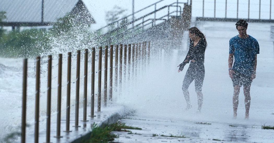
Hurricanes and tropical storms are defined by their powerful winds. But the storm surges they produce can often prove just as destructive in coastal communities.
Hurricane Ida was expected to create dangerous storm surges in parts of Louisiana and Mississippi.
Storm surge is defined as an abnormal rise in the ocean level generated by a storm, over and above the predicted astronomical tide. The surges are produced by ocean water moving inland, pushed by the force of the wind.
In the open ocean, hurricanes can pound the water without producing a surge. But near the coast, the shallower water is blown inland, threatening property and lives.
The highest surge will occur along the immediate coast in areas of onshore winds, where the high water will be accompanied by large and dangerous waves, the National Hurricane Center said.
The extent of surge-related flooding depends on the timing of the surge and the tidal cycle, and can vary greatly over short distances, the center said.
In 2008, Ike, a Category 2 hurricane that made landfall near Galveston Island in Texas, produced surges of 15 to 20 feet above normal tide levels, the center said. Property damage was estimated at $24.9 billion.
The National Hurricane Center said that areas that are placed under a storm surge warning are at risk of “life-threatening inundation.” People in those areas should heed any evacuation instructions from local officials, the center said.