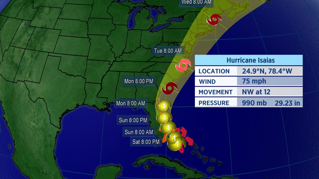
Hurricane warnings are in place across Florida’s eastern seaboard in advance of Isaias, the Atlantic’s second hurricane of the 2020 season, with impacts expected to be felt across the Floridian peninsula later on Saturday.
The storm could make mulitple landfalls as it moves north along the Eastern Seaboard into early next week.
Hurricane Isaias is moving across the Bahamas today and will approach Florida by late Saturday night into early Sunday morning.
Isaias was making its first landfall as a hurricane on Saturday afternoon, moving over Andros Island of the Bahamas as a Category 1 storm. However, wind shear appeared to give Isaias a more ragged-looking appearance on Saturday afternoon, and the storm’s maximum sustained winds weakened slightly as a result.
“High wind shear and dry air has taken its toll on the system,” Spectrum News chief meteorologist Mike Clay said on Saturday. “The center core is still intact, but the rest of the storm has been become weaker on satellite images.”
In Florida, a hurricane warning is now in place for areas from Boca Raton to the Volusia-Flagler County line. Tropical storm warnings are in for much of north Florida and into far southeastern Georgia, as well as Lake Okeechobee and parts of central Florida, including Orange, Osceola and Seminole Counties.
Storm surge watches are also now in place for parts of Florida’s east coast.

Hurricane Isaias’s forecast track.
The spaghetti models, a suite of computer forecast models overlayed on a map, show the storm is likely to turn north as it approaches Florida. Much of the East Coast will likely see impacts from Isaias, since rain and wind can extend far from the storm’s center.
Although Isaias should remain a hurricane while passing Florida, due to wind shear and dry air, the storm is not looking to intensify and could weaken while passing the Florida coast.
For now, the center of the forecast cone of uncertainty takes Isaias just east of Florida this weekend, though only a slight deviation of the current track could lead to a Florida landfall from Isaias this weekend. The Carolinas should see impacts early next week.
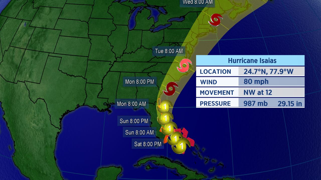
Hurricane Isaias’s forecast track.
Isaias has already brought heavy rainfall and gusty winds to the Bahamas, Virgin Islands, and Puerto Rico. At least five inches of rain fell in San Juan, Puerto Rico’s capital and largest city on Wednesday and Thursday, and hundreds of thousands of customers on the island lost power as Isaias moved through.
Exact Track Still Uncertain
Isaias has been on a steady west-northwestward to northwestward track, but that will change through the next couple of days. One bit of good news, with this particular storm, though: it’s small in size, which could limit the scope of its impacts.
“This is not a large hurricane in size, so the impacts will be concentrated close to where the center goes,” Spectrum News meteorologist Brian McClure said.
Confidence on the exact track still remains uncertain. Even if the center of the storm stays just offshore, Florida and the rest of the southeastern U.S. should closely monitor this system.
Impacts for mid-Atlantic and Northeast are also possible on Tuesday and Wednesday of next week.
“I expect the worst conditions along the North Carolina coast to occur late Monday through Tuesday morning,” Spectrum News meteorologist Matthew East said. “A few feet of storm surge looks likely in some areas, dependent on exactly where the center tracks.”
Isaias officially became the ninth-named storm of the Atlantic season and the earliest I-named storm on record. The previous record for the earliest ninth storm of the season was Irene, which formed on August 7, 2005.
It’s also the second hurricane of a busy to-date 2020 Atlantic season.
If you’re wondering how exactly Isaias is pronounced, here’s a detailed guide on how to properly say it (along with all the other 2020 Atlantic storms. In short, Isaias pronounced over four syllables: ees-ah-EE-ahs.
Keep checking in for the latest updates.