Hurricane Isaias formed early on Friday morning near the Turks and Caicos Islands, becoming the second Atlantic hurricane of an exceptionally busy hurricane season to date.

Hurricane Isaias’s forecast track.
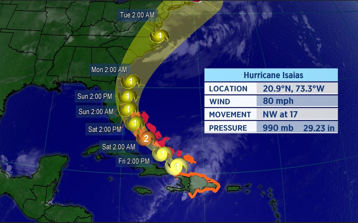
The center of Isaias has moved off the Dominican Republic and toward the southeastern Bahamas. The hurricane is moving fairly quickly as a ridge of high pressure steers it toward the northwest.
A tropical storm watch has been issued for parts of eastern Florida, including Miami and West Palm Beach. A watch means tropical storm conditions are possible within 48 hours.

Spaghetti model chart for Isaias as of early Friday morning.
The spaghetti models, a suite of computer forecast models overlayed on a map, show the storm is likely to gradually turn north as it approaches Florida. Tropical storm warnings are in place for much of the Caribbean, including the Dominican Republic, Haiti, the Turks and Caicos and the central and southeastern Bahamas.
With Isaias expected to continue to slowly strengthen, hurricane warnings were issued on Thursday night for The Bahamas. For now, the center of the forecast cone of uncertainty takes Isaias just east of Florida this weekend, though only a slight deviation of the current track could lead to a Florida landfall from Isaias this weekend.
Isaias has already brought heavy rainfall and gusty winds to the Virgin Islands and Puerto Rico. At least five inches of rain fell in San Juan, Puerto Rico’s capital and largest city, prompting numerous flash flood warnings across the island.
Winds in excess of 50 mph were recorded on Puerto Rico during the storm as well. Punta Cuna, located at the eastern tip of the Dominican Republic, recorded a 46 mph wind gust on Thursday afternoon as Isaias’s center passed just south of the city.
Forecast Remains Tricky
Isaias has been on a west-northwestward to northwestward track, but that will change through the next couple of days.
“There will be a dip in the jet stream moving into the southeastern U.S. which will help pull Isaias northward,” Spectrum News meteorologist Brian McClure said. “That is why the latest trends are for Isaias to drift by just east of Florida.”
Confidence on the track still remains uncertain. But, general trends continue to push the storm further east. Nonetheless, Florida and the rest of the southeastern U.S. should closely monitor this system.
Isaias officially became the ninth-named storm of the Atlantic season and the earliest I-named storm on record. The previous record for the earliest ninth storm of the season was Irene, which formed on August 7, 2005.
It’s also the second hurricane of a busy to-date 2020 Atlantic season.
If you’re wondering how exactly Isaias is pronounced, here’s a detailed guide on how to properly say it (along with all the other 2020 Atlantic storms. In short, Isaias pronounced over four syllables: ees-ah-EE-ahs.
Keep checking in for the latest updates.