After Tropical Storm Isaias brought local downpours and gusty winds to parts of Floriday yesterday, it’s forecast to re-strengthen into a hurricane today.
A hurricane warning has been issued from from the South Santee River in South Carolina to Surf City, North Carolina. In addition, a storm surge warning runs from Edisto Beach, South Carolina to Cape Fear, North Carolina
While Isaias brought generally minor impacts to Florida in a glancing blow on Sunday, the is forecast to re-strenghten into a hurricane and deliver more widespread and direct impacts, starting on Monday night along the Carolina coastline.
“After reaching the coast, it will accelerate northeastward over land toward the northeast U.S.” Spectrum News meteorologist Josh Linker said on Monday. “It will continue to weaken but will end up being a brief heavy rain maker from the Mid-Atlantic States to New England on Tuesday.”
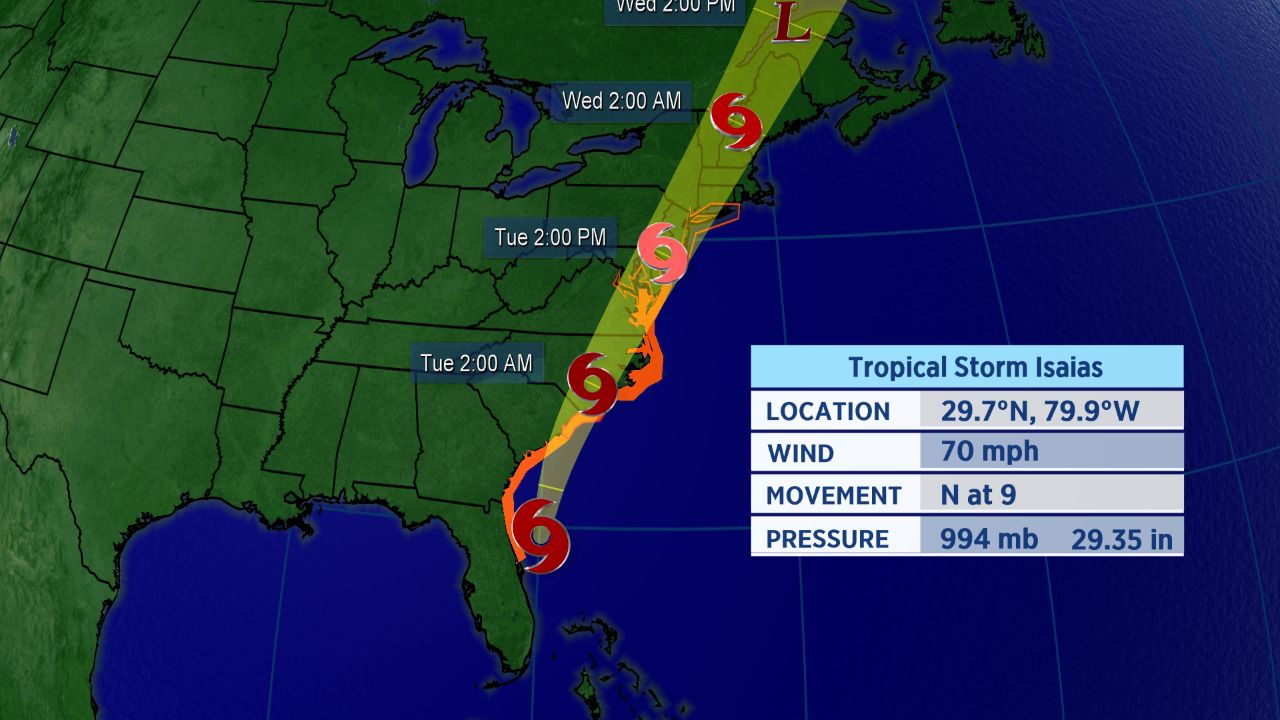
Forecast track for Isaias.
While conditions improve in Florida, the Carolinas will see impacts starting later today. People there can expect strong wind, heavy rain, storm surge along the coast, and flooding. As is often the case with landfalling hurricanes, a few tornadoes are also possible.
Tropical storm warnings run from the Flagler-Volusia County Line in Florida to South Santee River in South Carolina, then from Surf City, North Carolina to Watch Hill, Rhode Island. Other areas included are Chesapeake Bay south of North Beach, tidal Potomac River south of Cobb Island, Delaware Bay, Long Island and Long Island Sound, and Pamlico and Albemarle Sounds
Landfall is forecast to happen tonight somewhere near the North Carolina-South Carolina border.
Extent of Impacts Depends on Track
Isaias is starting to turn a little more northeast. One bit of good news, with this particular storm, though: it’s small in size, which could limit the scope of its impacts.
Another positive with the storm is its anticipated forward speed, which could exceed 25 mph by Tuesday. That should limit the duration of the storm’s impacts.
However, even after Isaias’s winds weaken, it will still cause the potential for significant issues as it runs northward.
Impacts for mid-Atlantic and Northeast are also likely on Tuesday and Wednesday.
“I expect the worst conditions along the North Carolina coast to occur late Monday through Tuesday morning,” Spectrum News meteorologist Matthew East said. “A few feet of storm surge looks likely in some areas, dependent on exactly where the center tracks.”
Isaias officially became the ninth-named storm of the Atlantic season and the earliest I-named storm on record. The previous record for the earliest ninth storm of the season was Irene, which formed on August 7, 2005.
The storm brought heavy rain and flooding, along with wind damage, to parts of the Caribbean. Hurricane warnings for the northwestern Bahamas were dropped Sunday morning as the storm moved away.
Isaias was the second hurricane of a busy to-date 2020 Atlantic season.
If you’re wondering how exactly Isaias is pronounced, here’s a detailed guide on how to properly say it (along with all the other 2020 Atlantic storms. In short, Isaias pronounced over four syllables: ees-ah-EE-ahs.
Keep checking in for the latest updates.