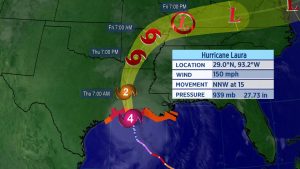
Hurricane Laura is expected to continue to strengthen as it moves through the Gulf of Mexico.
Landfall is expected late Wednesday night or Thursday morning along the Texas or Louisiana coastline, and hurricane warnings are now in place there ahead of the storm.
Laura Continues to Strengthen
Laura formed in the central Atlantic on Friday and has since moved into the Gulf of Mexico, quickly strengthening into a hurricane. Tropical storm warnings have been dropped from the Florida Keys since it has moved away from there.
Hurricane and tropical storm warnings have been issued for the Texas and Louisiana coastline.
Storm surge watches and warnings have also been issued along the coast of Texas, Louisiana, and Mississippi.
The governors of both Lousiana and Texas have preemptively declared disaster orders as they urge residents to monitor the forecast.

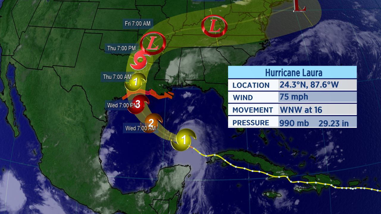
Hurricane Laura’s forecast track.
Now that Laura has entered the Gulf of Mexico, warm water and light wind shear will help it strengthen even more. It’s possible that it may attain “major” hurricane status, which happens when a storm becomes a Category 3 with winds of at least 111 mph.
Dangerous storm surge and heavy rain will also accompany Laura.

Arrival times of tropical-storm-force winds.
Tropical-storm-force winds are looking to arrive as early as Wedneday evening. If you are in the path of this storm, make sure to not wait until the last minute to make preparations. Today will be the last day to prepare for this hurricane.
Even though Laura is forecast to affect parts of the Gulf Coast as a hurricane, the exact details are still uncertain. The storm’s impacts will occur beyond the forecast cone, as well.

Spaghetti models continue to show some disagreement on where exactly Laura goes across the Gulf. Data have started to become more focused on east Texas to western Louisiana, though. We’ll have to keep a close eye on the storm and where it tracks.
Setting Records
Laura became the earliest “L” named storm to ever form in the Atlantic, and an M-named storm had never formed in the month of August in the Atlantic before Marco.
These storms follow what has already been a record-setting season in the Atlantic.
With 13 storms already this year, this is the fastest start to a hurricane season in recorded history. The climatological peak of hurricane season is in mid-September.
Since Marco made landfall on Tuesday, the tally this year is now six. If Laura tracks as expected, its landfall will be the seventh.
With Laura’s impending landfall on the Gulf Coast, here are five things you might not know about hurricanes.