Two storms affect the Gulf Coast this week with Tropical Storm Marco and Laura both moving toward U.S. shores.
Laura Expected to Strengthen
Tropical Storm Laura formed in the central Atlantic on Friday and continues to move on a northwesterly track as a ridge in the western Atlantic steers it. It’s moving briskly but will slow down as it moves into the Gulf of Mexico.
Tropical storm warnings are in place for parts of Cuba and the Florida Keys.
Hurricane and storm surge watches were issued for parts of the Louisiana and Texas coast on Monday afternoon. A tropical storm watch was issued for surrounding areas as well, including the city of Houston.
A watch means those conditions are possible within the next 48 hours.
Governors of both Lousiana and Texas have preemptively declared disaster orders as they urge residents to monitor the forecast.
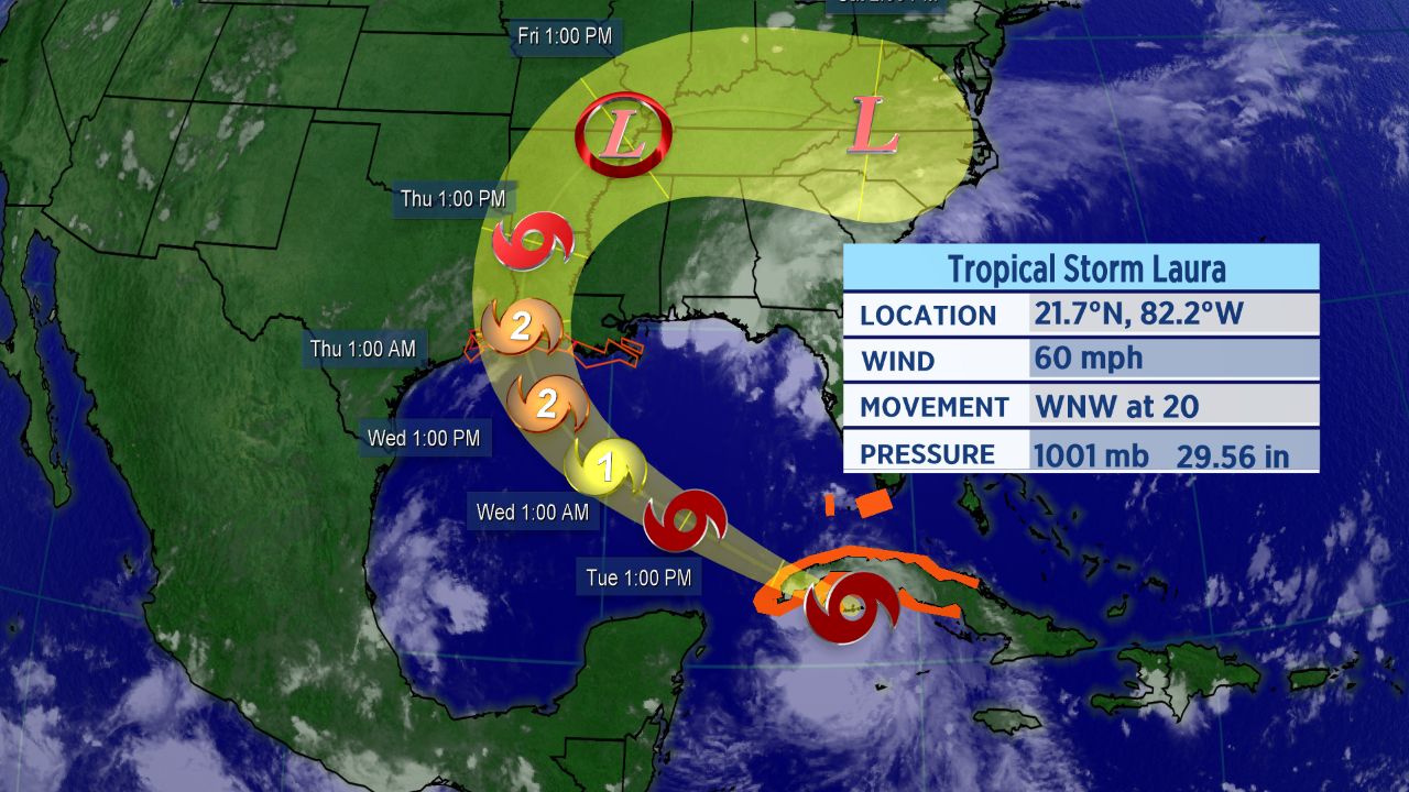
Forecast cone of Laura over the next five days.
Laura moved across Hispaniola over the weekend, bringing torrential rain, flash flooding, and mudslides. Heavy rain and gusty winds have been moving across Cuba.
At least 11 people people were reported dead in the Caribbean as Laura came through. It also knocked out power to hundreds of thousands on the island of Hispaniola.
Its intensity won’t change much for now as it moves near Cuba. As it moves into the Gulf of Mexico, it will enter more favorable conditions and we can expect to see strengthening.
This storm poses a threat to the Gulf Coast later this week, though the track and the storm’s strength are both uncertain. It’s possible Laura could approach major hurricane status as it nears the Gulf Coast.
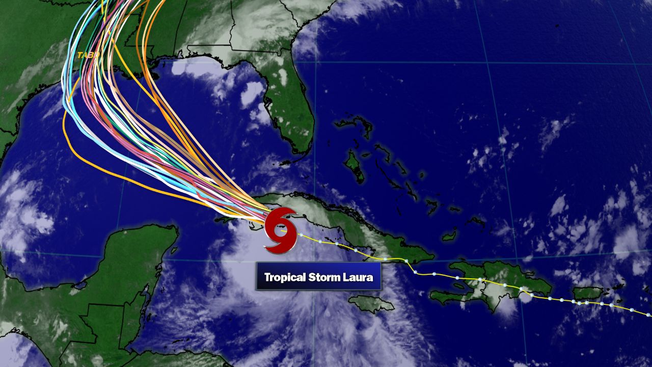
Spaghetti model tracks of Laura.
Spaghetti models continue to show some disagreement on where exactly Laura goes across the Gulf. Data show its path going anywhere from Corpus Christi, Texas to eastern Louisana. We’ll have to keep a close eye on the storm and where it tracks.
Marco Weakens
Tropical Storm Marco formed in the western Caribbean last Friday and and became the third hurricane of the Atlantic season over the weekend.
It’s run into a lot of wind shear since then, which has torn the system apart as it barely hangs on to tropical storm status Monday afternoon.
All tropical storm warnings and storm surge warnings that were in effect for Marco have been canceled.
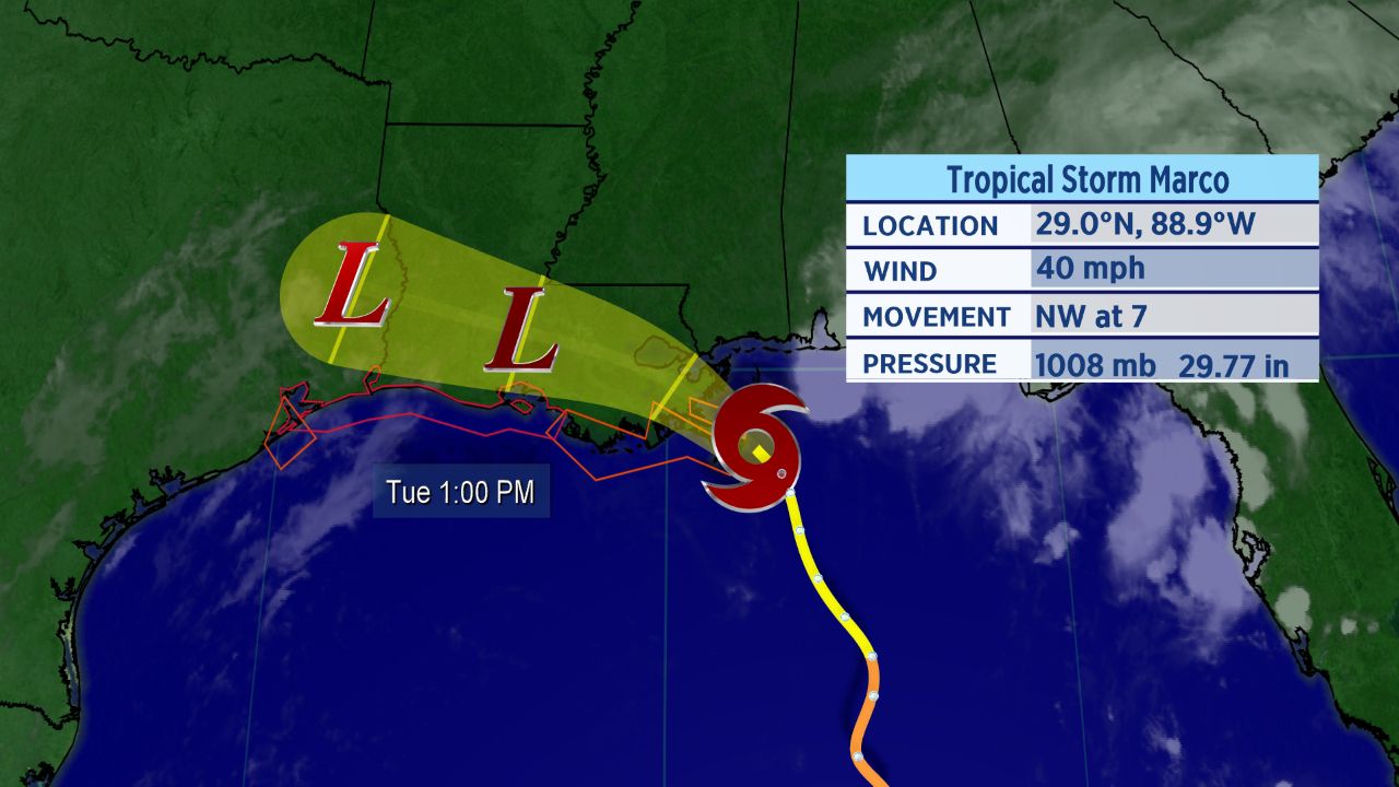
Forecast cone for Marco.
Marco is forecast to make landfall on the Louisiana coast into tonight, bringing gusty wind and locally heavy rain. The storm is expected to dissipate after moving inland.
Setting Records
Laura became the earliest “L” named storm to ever form in the Atlantic and an M-named storm had never formed in the month of August in the Atlantic before Marco.
These storms follow what has already been a record-setting season in the Atlantic.
With 13 storms already this year, this is the fastest start to a hurricane season in recorded history. The climatological peak of hurricane season is in mid-September.
If Marco and Laura make landfall as expected, the tally of landfalls so far this year would become seven.