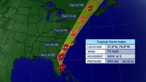
Isaias is rapidly moving up the East Coast, bringing the threat of heavy rain, damaging wind, and tornadoes to New England after leaving millions without power in its wake on Monday and Tuesday.
Tropical storm warnings remain from Watch Hill, Rhode Island to Eastport, Maine.
After an exceptionally windy and nasty Tuesday along much of the Eastern Seaboard, though, New York City, Boston, Philadelphia and Washington D.C. are no longer under tropical alerts. At one point on Tuesday, wind gusts up to around 80 mph led to nearly three million customers losing power on the East Coast.
Wind gusts Tuesday morning were as high as 78 mph at the southern tip of Manhattan, 70 mph at JFK Airport in New York, 68 mph near Atlantic City and Newark, New Jersey as well as at the NASA Wallops Flight Facility in Virginia.
The storm intitially came ashore as a hurricane late Monday night, with maximum sustained winds of 85 mph near Ocean Isle Beach, North Carolina, about 20 miles southwest of Wilmington. Winds at Oak Island, North Carolina gusted to nearly 90 mph as Isaias moved onshore.
North Carolina also experienced heavy rain as Isaias came in.
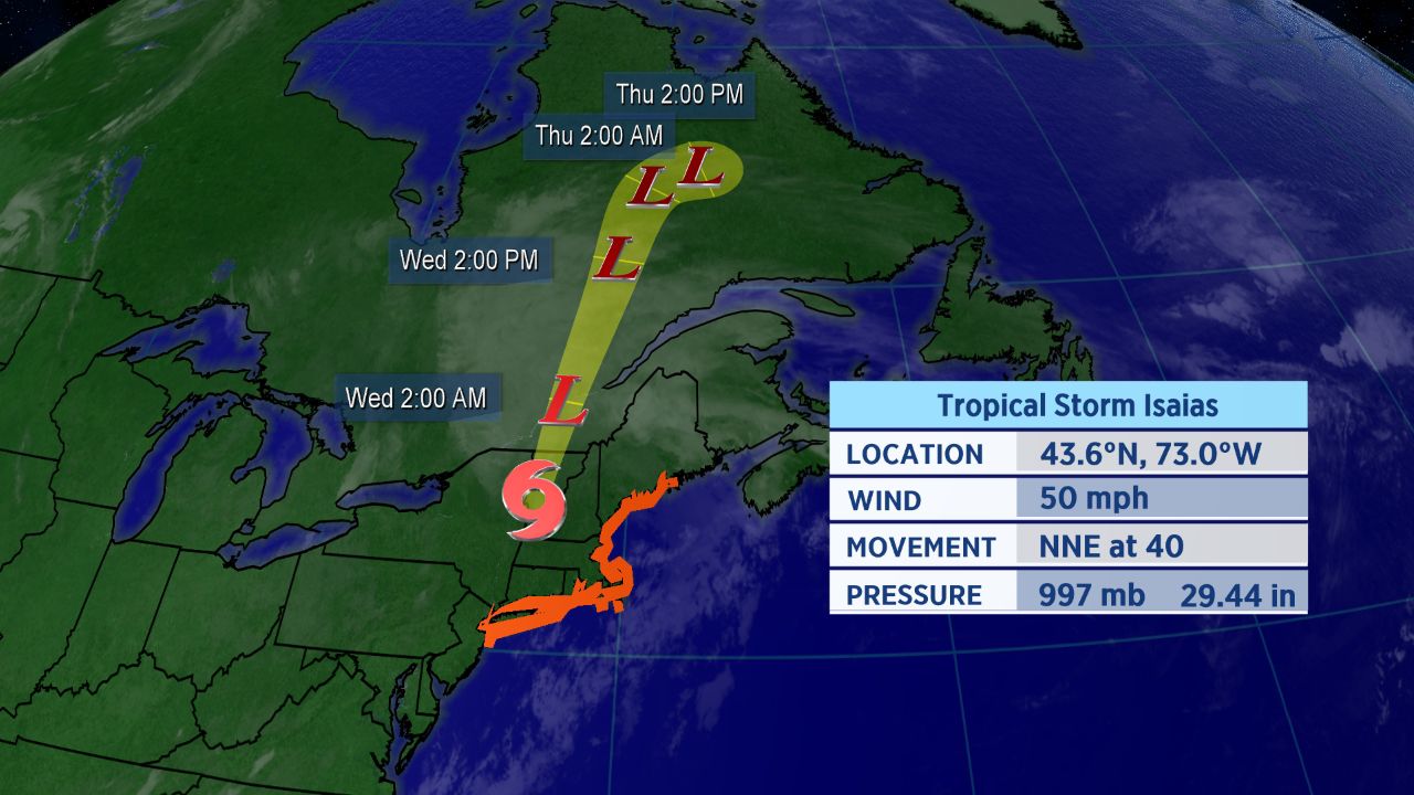
Tropical Storm Isaias’s forecast track
Storm Won’t Stay Around Long
Isaias is moving quickly, now zipping to the northeast at 40 mph. That will limit how long the storm’s impacts stay around.
However, even as Isaias weakens and accelerates, the potential for significant issues spreads north.
Strong winds and heavy rainfall will move through New England into Tuesday night. A tornado watch is in effect until 9 p.m. for areas of Upstate New York, Massaschusetts, Connecticut, and Rhode Island.
The spaghetti model plot shows that many computer forecasts show Isaias tracking over the Northeast megalopolis. Impacts will extend beyond those areas, though.
Isaias officially became the ninth-named storm of the Atlantic season and the earliest I-named storm on record. The previous record for the earliest ninth storm of the season was Irene, which formed on August 7, 2005.
Isaias was the second hurricane of a busy to-date 2020 Atlantic season.
If you’re wondering how exactly Isaias is pronounced, here’s a detailed guide on how to properly say it (along with all the other 2020 Atlantic storms. In short, Isaias pronounced over four syllables: ees-ah-EE-ahs.
Keep checking in for the latest updates.