Tropical storm warnings remain from Florida’s east coast and now extend all the way up to North Carolina. Isaias, previously the Atlantic’s second hurricane of the 2020 season, will continue to bring gusty winds and heavy rain to parts of Florida today.
Even as a tropical storm, locally heavy rain and gusty winds will occur along the east coast of Florida. Through Sunday afternoon, top wind gusts were near tropical storm levels from Boca Raton to Port St. Lucie.
Storm surge of two-to-four feet is also possible, mainly from Jupiter Inlet to Ponte Vedra Beach.

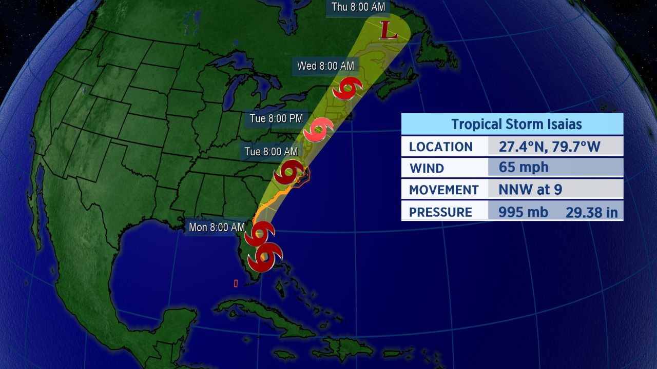
Forecast track for Tropical Storm Isaias.
Isaias is turning northward, skirting the Florida coast as it does so. As it rounds around a weak ridge in the Atlantic, it’ll gradually turn to the northeast in a couple of days.
The storm is looking to bring impacts to Florida throughout Sunday and into Monday.
Tropical storm warnings run from Jupiter Inlet, Florida to Surf City, North Carolina. A tropical storm watch extends north to Duck, North Carolina and includes Pamlico and Albemarle Sounds.
Storm surge watches for Florida’s east coast are no longer in place. However, they have been added for areas from Edisto Beach, South Carolina to Cape Fear, North Carolina.
For now, the center of the forecast cone of uncertainty takes Isaias up the east coast of Florida. The Carolinas should see impacts early in the week.
Extent of Impacts Depends on Track
Isaias has been on a steady west-northwestward to northwestward track, but that will change through the next couple of days. One bit of good news, with this particular storm, though: it’s small in size, which could limit the scope of its impacts.
Even though Isaias is no longer a hurricane, it will still cause issues as it runs northward.
Impacts for mid-Atlantic and Northeast are also possible on Tuesday and Wednesday of next week.
“I expect the worst conditions along the North Carolina coast to occur late Monday through Tuesday morning,” Spectrum News meteorologist Matthew East said. “A few feet of storm surge looks likely in some areas, dependent on exactly where the center tracks.”
Isaias officially became the ninth-named storm of the Atlantic season and the earliest I-named storm on record. The previous record for the earliest ninth storm of the season was Irene, which formed on August 7, 2005.
The storm brought heavy rain and flooding, along with wind damage, to parts of the Caribbean. Hurricane warnings for the northwestern Bahamas were dropped Sunday morning as the storm moved away.
Isaias was the second hurricane of a busy to-date 2020 Atlantic season.
If you’re wondering how exactly Isaias is pronounced, here’s a detailed guide on how to properly say it (along with all the other 2020 Atlantic storms. In short, Isaias pronounced over four syllables: ees-ah-EE-ahs.
Keep checking in for the latest updates.