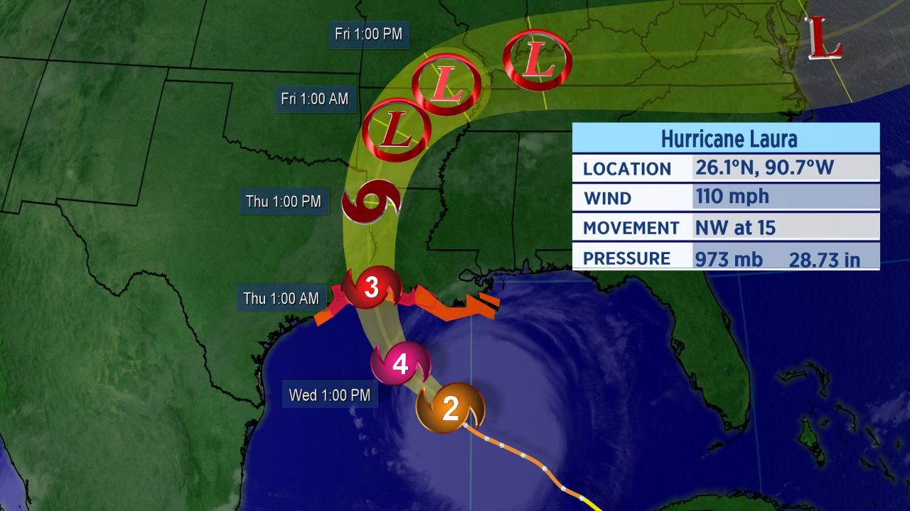
Hurricane Laura gained strength overnight and is forecast to become a Category 4 hurricane today.
Landfall is expected Wednesday night along the southeastern Texas or southwestern Louisiana coastline, and hurricane warnings are now in place there ahead of the storm.
Laura Continues to Strengthen
Laura formed in the central Atlantic on Friday and has since moved into the Gulf of Mexico, quickly strengthening into a hurricane.
Hurricane warnings run from San Luis Pass ,Texas to Intracoastal City, Louisiana. Storm surge warnings are in place from Freeport, Texas to the mouth of the Mississippi River in Louisiana.
Tropical storm warnings and storm surge watches are in effect either side of those areas.
The governors of both Lousiana and Texas have preemptively declared disaster orders as they urge residents to monitor the forecast.

Forecast cone for Hurricane Laura.
Warm water and light wind shear will help it strengthen even more. It will attain “major” hurricane status, which happens when a storm becomes a Category 3 with winds of at least 111 mph. There’s a real potential it will even reach Category 4 status with sustained winds near 130 mph before falling back a bit before landfall.
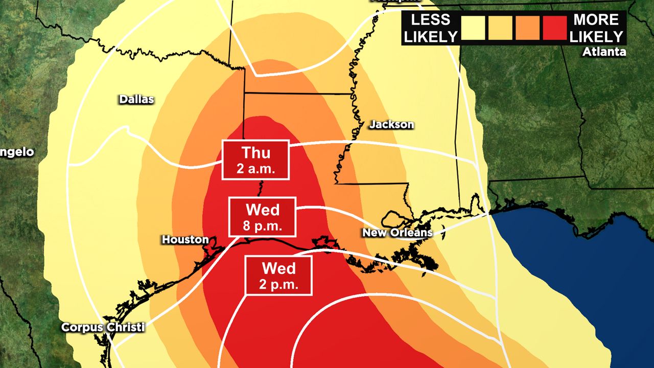
Most likely arrival time of tropical storm-force wind.
Tropical storm-force winds are looking to arrive by this evening. Final preparations and evacuations should be completed by midday on Wednesday at the absolute latest.
Laura is a large hurricane, so strong wind will extend far from the center and beyond the forecast cone. Hurricane-force winds reach as far as 70 miles from the storm’s center, and tropical storm-force winds are up to 175 miles away.
Dangerous storm surge and heavy rain will also accompany Laura. Reasonable worst-case storm surge is 10 to 15 feet above ground level near the landfall location and flooding could spread far inland.
Even though Laura is forecast to affect a sizeable share of the Gulf Coast, the exact landfall location is still uncertain. That said, it is likely that the storm will make landfall near the Texas and Louisiana border as a major hurricane tonight.
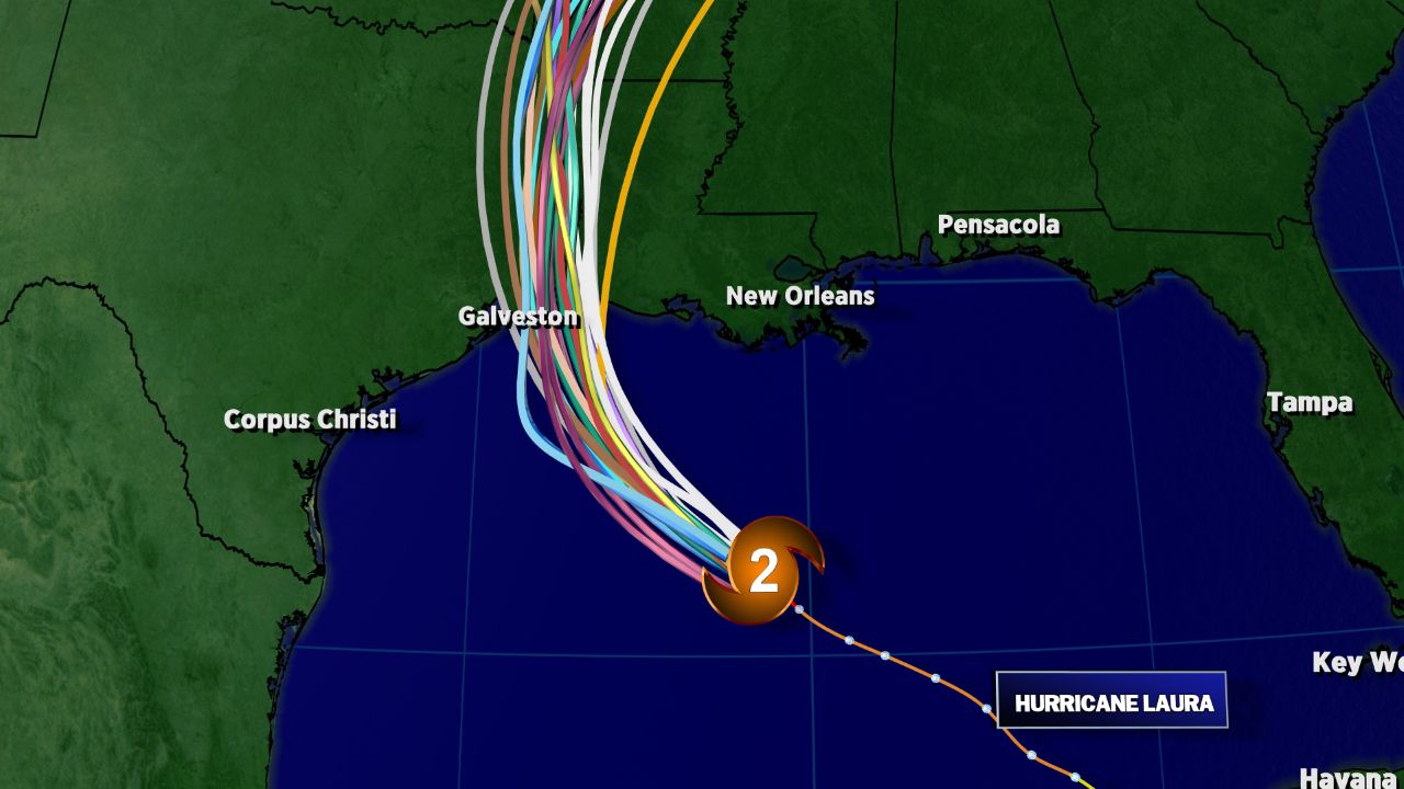
Spaghetti models for Hurricane Laura.
Spaghetti models have become focused in a narrower area for landfall. Data continue to become more focused on east Texas to western Louisiana, though, potentially sparing the immediate Houston metro area the worst of Laura’s impacts.
We’ll have to keep a close eye on the storm and where it tracks.
Setting Records
Laura became the earliest “L” named storm to ever form in the Atlantic, and an M-named storm had never formed in the month of August in the Atlantic before Marco.
These storms follow what has already been a record-setting season in the Atlantic.
With 13 storms already this year, this is the fastest start to a hurricane season in recorded history. The climatological peak of hurricane season is in mid-September.
Since Marco made landfall on Tuesday, the tally this year is now six. If Laura tracks as expected, its landfall will be the seventh.
With Laura’s impending landfall on the Gulf Coast, here are five things you might not know about hurricanes.