Hello Friday! Wrapping up the week with more rain chances and below average temperatures.
Last night rain moves through the state with some showers lingering in eastern Ohio through the morning. Give yourself extra time this morning with wet roads possible especially in eastern parts of the state. Temperatures begin in the 40s.

Once this rounds tapers off by mid/late morning, we’ll be tracking another chance of showers and storms this afternoon. Scattered chances develop after lunchtime, between 2-5 PM, in western Ohio. Showers and storms push through the state this evening.
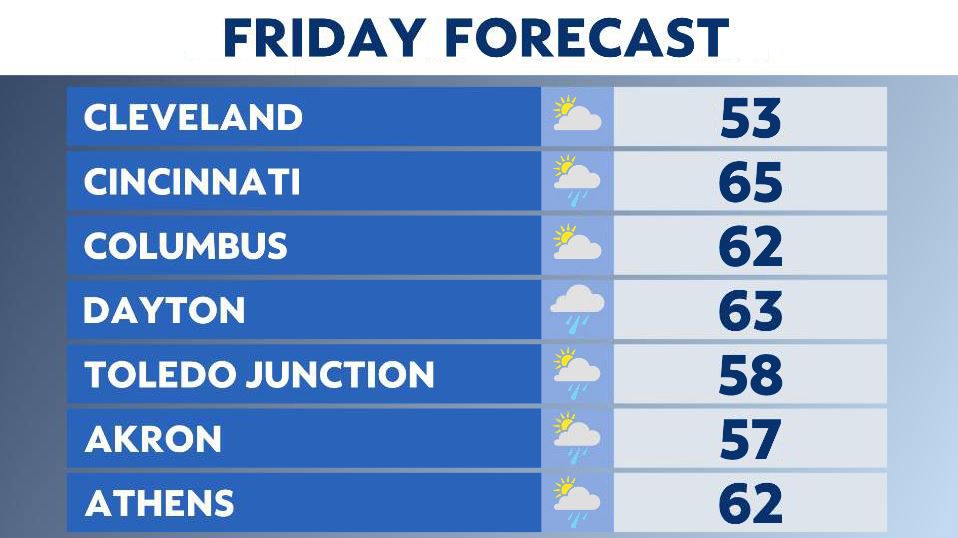
Highs today in the 50s to lower 60s.
Showers and storms possible tonight but the good news is wet weather moves out by tomorrow!
Saturday looks dry and the best chance to be outside! Highs remain below average but will feel like spring in the 50s to mid 60s.

By Saturday night our next round of widespread rain arrives into the Ohio valley.

Sunday is wet and chilly with rounds of rain through the day and cooler temperatures. Highs only in the 50s to barely 60 in southern Ohio.
More frost?
Cool overnight lows will fall into the 30s again Friday night into Saturday morning.

Depending on how fast the rain clears out, we could see some frost. The daytime hours of Saturday look good with rain coming in late.
This round will be more prolonged and produce moderate or even heavy rainfall through Sunday night.
We do expect some drying skies early next week.