Rain is likely to be a big part of the upcoming week ahead, with the potential for flooding by Wednesday in parts of the state.
Although we’ve seen our fair share of showers and storms this past week, they’ve been of the pop-up variety. A true cold front will be moving in Monday, giving us a chance for statewide widespread rain and storms.
Monday afternoon’s storms could be strong to severe in spots, with heavy rain, gusty winds and large hail. The tornado threat is low but is not zero. Very warm air and the clash of the cooler air along and behind the approaching front will keep instability levels on the higher side.
By Tuesday, scattered showers will continue along with a few storms. Temperatures will start dramatically cooling down as well, with 70s replacing many 80 and 90 degree highs.
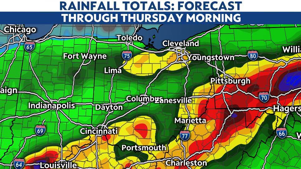
Wednesday is where things may get interesting, as we track what will be the remnants of Hurricane Ida. As it moves up across the Mid-South and Ohio Valley, it will give areas south of I-70, especially across SE Ohio, a chance for heavy, even flooding rain.
It’s certainly possible that we could see 2-5″ along the West Virginia border by late Wednesday into Thursday.
Stay tuned as we track these developments and fine-tune the rainfall forecast heading into the week ahead.

By the end of next week, we’re expecting a slight cool-down, although temperatures will remain average or even slightly above well into next weekend.