As millions prepare for the Christmas holiday weekend, we are tracking a powerful winter storm that will disrupt travel plans from the Plains to the Midwest to the Eastern Seaboard.
Plus, the storm will send temperatures plunging, providing a white but very cold Christmas to several areas across the nation.
Many will deal with rain, snow and wind, not to mention some frigid temperatures.
Dangerous December chill
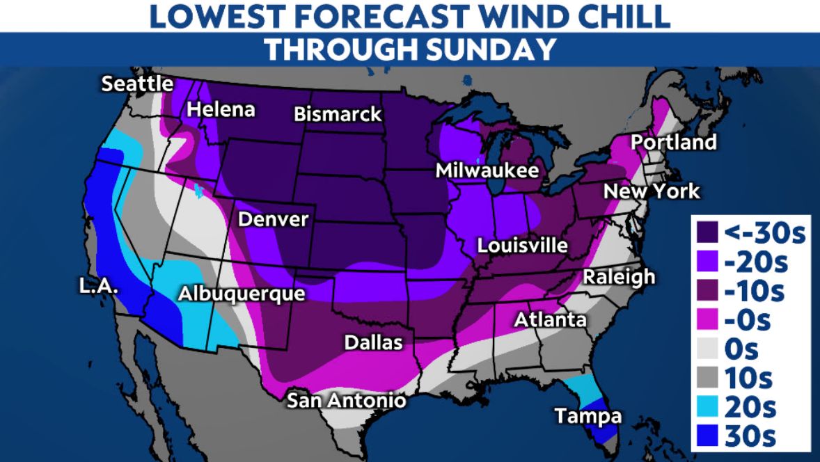
An arctic air mass will send subzero temperatures and blistering wind chills for the Plains and some parts of the Midwest, and we could see lows colder than 20 degrees reach all the way to the Gulf coast. For many, this cold will reach dangerous levels because of short frostbite times or because people simply aren’t used to it.

Bitterly cold air is already spilling into the Northern Rockies and will bulldoze its way south and east in the coming days. Some will see temperatures drop by more than 30 degrees in a matter of hours. Record cold temperatures will fall, as well.

Temperatures on Friday will be more than 30 degrees below normal in a huge swath from the Canadian border to the Gulf of Mexico. The Electric Reliability Council of Texas (ERCOT) says it expects to be able to meet electricity demand there, a concern still fresh in Texans’ minds after the massive power failure in Feb. 2021.
Where readings will rapidly fall below freezing after having precipitation, plan on roads flash-freezing. This means they’ll quickly turn icy, and road treatments may not be effective.
Cold temperatures will remain widespread on Christmas Day, slowly moderating thereafter.
A wintry mess, including a blizzard
While it’s hard to nail down the exact timing and details, this nasty system will snarl travel, both on the road and in the air.
The latest data seems to suggest it will produce everything from heavy rain and snow, as well as powerful winds and even the potential for thunderstorms.
Snow is carrying over into the Midwest, Great Lakes and Ohio Valley through Friday. Blizzard conditions are expected in parts of the Northern Plains, Upper Midwest and Great Lakes.
The combination of wind and cold will make how much snow falls almost irrelevant, since the impacts will essentially be the same: very poor, if not impossible, travel conditions.

Snow and strong winds Thursday into Friday will likely send travel issues cascading across the country. Chicago’s O’Hare and Midway airports said they have 350 pieces of equipment and 400,000 gallons of pavement de-icing fluid between them to keep runways and taxiways clear, the Associated Press reports.
The same weather system will produce rain–possibly heavy–and even some thunderstorms from the Southeast all the way up to New England later this week.

Strong winds could down tree limbs and cause power outages thanks to peak wind gusts over 50 mph.
Be prepared
If you must travel by car, pack an emergency winter survival kit.
Because strong winds could knock out power, know how to extend your phone’s battery life.
If you live where frozen pipes could become an issue, do what you can to protect them.
Check in on your local forecast often to stay aware of what you can expect, and turn on weather notifications to be alerted to significant weather.