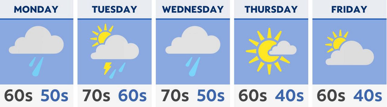
Spring finally arrives and lasts more than just a day with most of the week’s highs in the 60s and 70s.
What You Need To Know
- This week’s highs track 10 degrees above normal temperatures
- Average highs range from the upper 50s to lower 60s this time of year
- Daily chances of rain and some storms
- Driest day is Friday with the sun returning and temperatures are seasonable
Our pattern is active starting Monday morning with a round of rain and storms. Give yourself extra time during your morning commute with heavier rain possible along with some thunder. This could cause some slow downs.
Into Monday afternoon, chances are scattered for rain and a few more storms as highs soar into the 60s and 70s, alot warmer than the weekend.
Keep the umbrella close most of the week, because there will be daily chances of wet weather including some storms.
Later in the day Tuesday, another round develops of rain with a few storms. Those chances linger into Wednesday.
A bigger storm arrives Wednesday, so wet weather is likely with some stronger to severe storms along a passing cold front. Stay weather ready Wednesday through Wednesday night.
If storms become stronger to severe they could produce damaging wind gusts, hail and an isolated tornado can’t be ruled out with the system.
Conditions are still soggy for Thursday with mainly the chance of rain as temperatures are in the 60s to near 70.
The driest day is Friday with a cooldown. Highs drop back to average in the lower to mid 60s with the sun finally returning.