Tropical Storm Isaias officially formed late on Wednesday night in the eastern Caribbean, continuing an historically busy start to the 2020 Atlantic hurricane season. Mainland U.S. impacts are possible this weekend, though high forecast uncertainty remains.
After a lengthy stretch as a disorganized tropical wave, Tropical Storm Isaias finally formed about 150 miles off the southern coast of Puerto Rico.
“The tropical wave that we’ve been tracking for the past week has finally been declared Tropical Storm Isaias,” said Spectrum News meteorologist Brian McClure. “For many days we’ve know this was a robust tropical wave, but it took a long time for the southern end of the wave to fully circulate and form a center.”

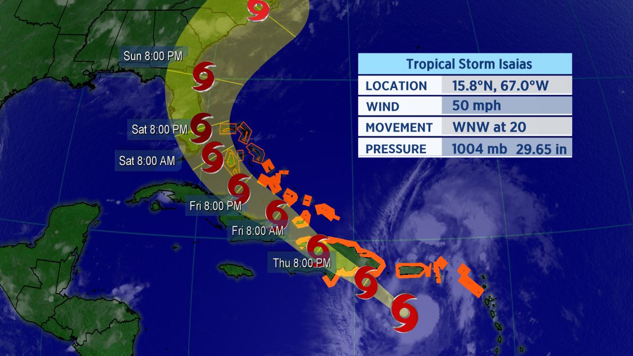
Forecast cone for Tropical Storm Isaias.
The storm was located just south of Puerto Rico as of late Wednesday night, and it was moving briskly to the west-northwest across the the eastern Caribbean. A ridge of high pressure located northeast of the storm kept its forward speed at about 20 mph as of Wednesday night, which is relatively fast for a tropical system.
Isaias became the ninth-named storm of the Atlantic season, and therefore, it also became the earliest I-named storm on record. The previous record for the earliest ninth storm of the season was Irene, which formed on August 7, 2005.
If you’re wondering how exactly Isaias is pronounced, here’s a detailed guide on how to properly say it (along with all the other 2020 Atlantic storms. In short, Isaias pronounced over four syllables: ees-ah-EE-ahs.
The spaghetti models, a suite of computer forecast models overlayed on a map, show the storm is likely to gradually turn north as it moves westward across the Atlantic.
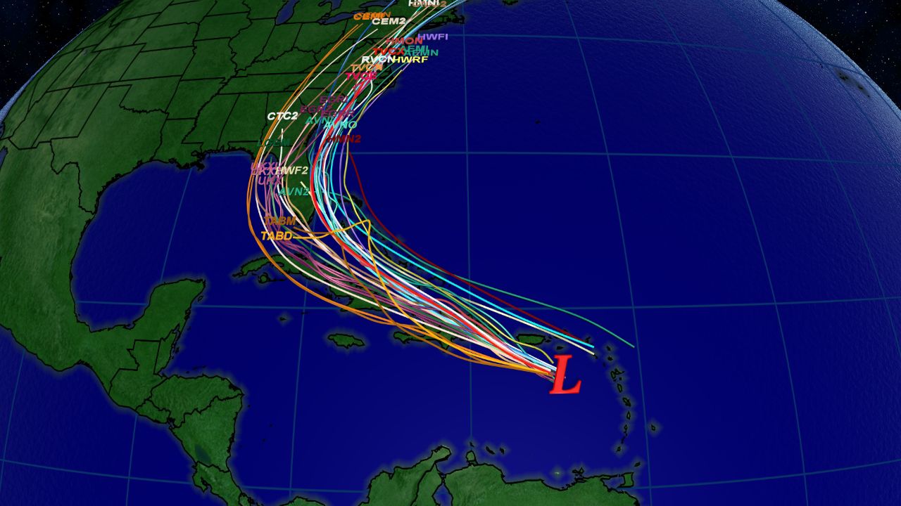
Spaghetti model tracks as of Wednesday afternoon.
Tropical storm warnings are in place for much of the Caribbean, including the islands of Puerto Rico, U.S. and British Virgin Islands, St. Martin, St. Barthelemy, Saba and St. Eustatius, St. Maarten, the Dominican Republic, Haiti, Turks and Caicos, and the central and southeastern Bahamas.
Heavy rainfall and gusty winds will spread eastward from the Virgin Islands and Puerto Rico into Thursday. A 52 mph wind gust was recorded on Saint Thomas in the U.S. Virgin Islands on Wednesday, and San Juan, Puerto Rico recorded a 44 mph wind gust as well.
Forecast Remains Tricky
Most computer forecast models show Isaias slowly strengthening this week, although its long-term forecast is still highly uncertain. The track – and the storm’s intensity – will depend on where exactly the center of the system passes through, and specifically, whether or not it moves over the highly mountainous island of Hispaniola.
Current projections show a possible Thursday interaction between Isaias and Hispaniola, which could quickly weaken the storm.
Also, because the storm lacked a well-defined center of circulation until Wednesday night, computer forecast models continue to struggle to forecast the storm – and adding to forecast uncertainty.
The current forecast cone shows the potential for a landfall on Florida this weekend. Interests in Florida and throughout the southeastern U.S. should be closely monitoring this system.