Hurricane Laura made landfall over Cameron, Louisiana early on Thursday morning as a powerful Category 4 storm, making it one of the strongest hurricanes to make a U.S. landfall in recent memory.
Daylight has begun to show the damage coming out of the area. One death has been reported so far.
The storm was downgraded to a tropical storm on Thursday afternoon, but the flood and wind threat will remain considerable for many in Laura’s path as the storm pushes inland.
Laura Makes Landfall, Impacts Spread Inland
Laura officially made landfall as a high-end Category 4 hurricane at 1 a.m. CT on Thursday morning near Cameron, Louisiana, making it the strongest hurricane to make landfall on Louisiana since 1856.
Laura’s maximum sustained winds were estimated to be 150 mph, putting the storm into rare territory in terms of landfalling U.S. hurricanes.
Wind speeds up to 127 mph were recorded in Cameron as Laura’s northern eyewall moved through the city early on Thursday morning. Nearby Lake Charles, Louisiana recorded a wind gust of 133 mph on Thursday morning as well.
Authorities are already out assessing damage, including in the Lake Charles area.
On Wednesday morning and ahead of the storm, the National Hurricane Center referred to the storm surge threat from Laura as “unsurvivable.” Up to 20 feet of storm surge was expected to flood much of southwestern Louisiana and far southeastern Texas.
While the storm surge threat is subsiding, the threat could continue over the next few hours.
Flooding could spread as far as 40 miles inland and it’s not expected to recede for days.
The governors of both Lousiana and Texas preemptively declared disaster orders.

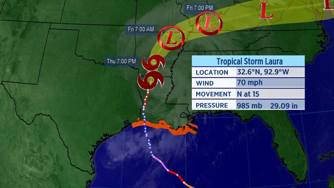
Forecast cone for Tropical Storm Laura.
Laura is a large storm, so strong winds will extend far from the center and beyond the forecast cone. Tropical storm-force winds extend up to 100 miles away from the storm’s center.
By this evening, even though Laura will weaken more, northern Louisiana and Arkansas will continue to see strong wind gusts.
Today’s threat of excessive rain and flooding reaches as far north as Arkansas.
Category 4 Landfalls Are Rare
Since 1851, only 26 hurricanes of a Category 4 or 5 strength have made landfall on the continental United States. That means that a Category 4 or 5 landfall on the United States takes place only once every six or seven years.
Since 1851, Louisiana has had only three Category 4 hurricanes make landfall, according to Colorado State Univeristy hurricane researcher Dr. Phil Klotzbach.
No Category 5s on record have hit the state, according to Klotzbach.
Since 1894, Louisiana has only seen one Category 4 landfall, Hurricane Betsy back in 1965.
Klotzbach also noted that Laura is the strongest August Gulf of Mexico hurricane since Hurricane Katrina in 2005.
Setting Records
Laura became the earliest “L” named storm to ever form in the Atlantic, and an M-named storm had never formed in the month of August in the Atlantic before Marco.
These storms follow what has already been a record-setting season in the Atlantic.
With 13 storms already this year, this is the fastest start to an Atlantic hurricane season in recorded history. The climatological peak of hurricane season is in mid-September.
With Marco and Laura making landfall, the tally is now up to seven.
As Laura continues to hit parts of the Gulf Coast region hard, here are five things you might not know about hurricanes.