After a mainly cloudy and cool day, with scattered showers especially across central and southern Ohio, we’ll see some clearing overnight with another round of patchy frost– this time in far NW Ohio.
What You Need To Know
- Cooler than average weather continues
- We’ll track a few scattered shoowers Sunday
- A wintry mix is possible Wednesday morning
- Milder weather is likely for the end of next week
Sunday morning gives us chilly temperatures, with lows bottoming out in the upper 30s and low 40s. After a break from the mostly overcast skies early on, we’ll see thickening afternoon clouds, with a few scattered light showers and sprinkles developing once again in the afternoon.
Most of the light rain will be confined east of the I-71 corridor. Expect some late clearing Sunday evening.
By Monday, most areas should see some sunshine with milder temperatures. Highs Monday afternoon should reach the mid 60s, with light winds and mostly sunny skies prevailing. Increasing clouds roll back in ahead of our next front by Tuesday morning.
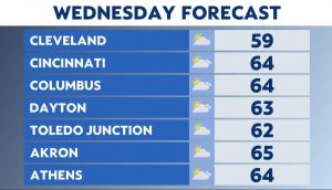
Things start to get interesting by Tuesday night into Wednesday, with rain mixing with, and eventually changing to snow in many areas across the state.
While temperatures may get close to freezing, most of what falls shouldn’t accumulate, although we could see some very light amounts on the tops of cars and perhaps grassy surfaces. Wednesday evening, we’ll begin the slow clearing process.
After a “cameo” appearance by Winter on Wednesday, skies brighten up and temperatures moderate for the remainder of the week and into next weekend.