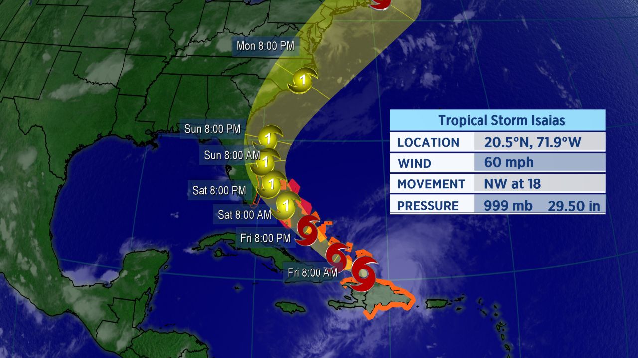
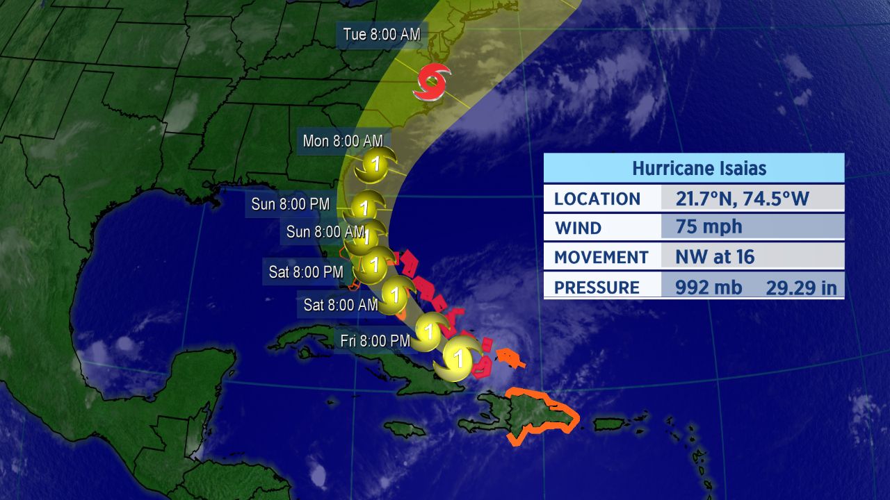
Tropical Storm Isaias continues to move northwest, now heading toward the Bahamas. Mainland U.S. impacts are possible this weekend, though high forecast uncertainty remains.
Forecast path for Tropical Storm Isaias.
The center of Isaias has moved off the Dominican Republic and toward the southeastern Bahamas. The tropical storm is moving fairly quickly as a ridge of high pressure steers it toward the northwest.
A tropical storm watch has been issued for parts of eastern Florida, including Miami and West Palm Beach. A watch means tropical storm conditions are possible within 48 hours.
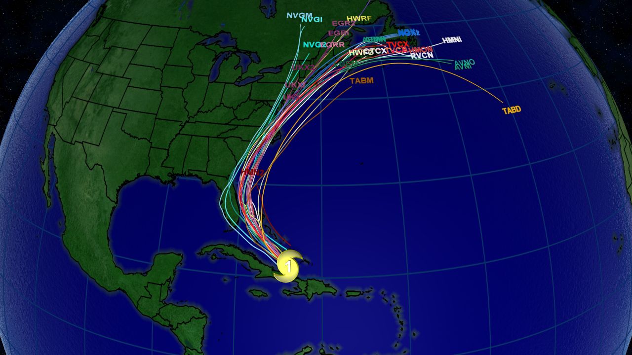
Spaghetti model chart for Isaias as of late Thursday evening.
The spaghetti models, a suite of computer forecast models overlayed on a map, show the storm is likely to gradually turn north as it approaches Florida.Tropical storm warnings are in place for much of the Caribbean, including the Dominican Republic, Haiti, the Turks and Caicos and the central and southeastern Bahamas. With Isaias now expected to strengthen, hurricane warnings were issued on Thursday night for the northwestern Bahamas.
Isaias has already brought heavy rainfall and gusty winds to the Virgin Islands and Puerto Rico. At least five inches of rain fell in San Juan, Puerto Rico’s capital and largest city, prompting numerous flash flood warnings across the island.
Winds in excess of 50 mph were recorded on Puerto Rico during the storm as well. Punta Cuna, located at the eastern tip of the Dominican Republic, recorded a 46 mph wind gust on Thursday afternoon as Isaias’s center passed just south of the city.
Forecast Remains Tricky
A high pressure ridge over the eastern Atlantic will continue to steer Isaias west-northwestward to northwestward over the next couple of days.
On Friday, a trough moving into the eastern U.S. will weaken the western portion of the ridge and cause Isaias to steer more north-northwestward. As the trough slides more to the east, this will help steer Isaias more northeastward.
Confidence on the track still remains uncertain due to the possible interaction with land. But, general trends continue to push the storm further east. Nonetheless, Florida and the rest of the southeastern U.S. should closely monitor this system.
Isaias officially became the ninth-named storm of the Atlantic season and the earliest I-named storm on record. The previous record for the earliest ninth storm of the season was Irene, which formed on August 7, 2005.
If you’re wondering how exactly Isaias is pronounced, here’s a detailed guide on how to properly say it (along with all the other 2020 Atlantic storms. In short, Isaias pronounced over four syllables: ees-ah-EE-ahs.
Keep checking in for the latest updates.